The Institute of Meteorology will maintain strict monitoring of this situation throughout the weekend, recommending the population of the western provinces to keep the official notices attentive attentive
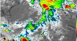
The satellite image shows the extroatropical decline in the Gulf of Mexico. (Photo: INSMET)
The Institute of Meteorology of Cuba (Insmet) on Friday about the formation of a decline or an extroatropical cyclone in the Gulf of Mexico, a weather system that presents an associated cold front and an active prefrontal trough. This atmospheric pattern is already generating significant activity of showers, rains and thunderstorms in the region.
According to the forecasts, in the next few days this system will move to the southeast of the United States, while the Associated Cold Front will approach the western region of Cuba.
This configuration will cause the formation of showers, rains and thunderstorms, some of which could be strong and intense. The information emphasizes that the possibility of severe local storms in some areas is not ruled out.
Insmet will maintain strict monitoring of this weather situation throughout the weekend, recommending to the population of the western provinces keep the official notices attentive.
(With information from the Institute of Meteorology)


