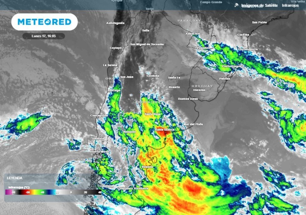
Perhaps the most particular week of all of 2024 began in Argentina, in which of the usual 5 business days, 3 will be holidays. The first holiday in progress this Monday the 17th, due to the Passage to Immortality of General Martín Güemes, passes with very different weather conditions in the countrywhich range from an extremely cold south of Argentina with snowfall, to a humid and pleasant north with isolated storms.
In the southern portion of Patagonia, Tierra del Fuego and southern Santa Cruz are being affected by an extremely cold and dry air mass. Rio Grande (Tierra del Fuego), for example, recorded a minimum temperature below 10 °C below zero, and In the middle of a Monday afternoon it still maintained icy marks of 4 °C below zero and less than 7 °C below zero in thermal sensation, despite having sunny conditions.
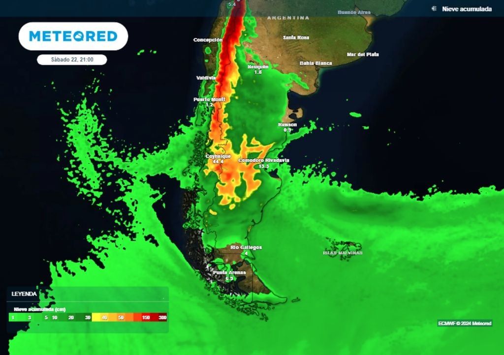
Towards the center and north of Patagonia, a broad low pressure system is entering that generates rain and snowfall, under alert conditions. The most relevant situation occurs in terms of snow, with a orange level alert for this extended day in the Neuquén mountain range, where more than 60 cm could accumulate between today and tomorrow.
The official alert, but at a yellow level, extended both to the north over the Mendoza mountain range and to the south over a good part of the rest of the Patagonian mountain range, but What will really be surprising about this event is how a good amount of snow will accumulate in low areas of the Santa Cruz and Chubut plateau, even in coastal areas, where accumulations that could be between 10 and 30 are expected in the next few hours. mm.
A yellow level meteorological alert is in effect due to this particular situation in low areas of southern Patagonia. Towards Tuesday the snow will gain ground in the Chubut province, and Snowfall is expected in cities like Comodoro Rivadavia, accompanied by strong southeasterly winds with gusts of more than 70 km/h.
Snow can be a big protagonist this week in not so common places in Patagonia, such as the city of Comodoro Rivadavia.
In northern Argentina, on the other hand, there are humid and mild conditions, with marks of 20 to 25 °C on Monday afternoon. The presence of a stationary frontal system over the northern coast maintains highly unstable conditions, with isolated formation of storms that can be locally strong..
The most committed sector between this Monday and Tuesday is limited to the province of Misiones and the east of Formosa, and to a lesser extent the north of Corrientes, where there may be strong pockets of storms with hail and/or gusts in a localized manner.and abundant precipitation accumulations in short periods, with rainfall greater than 50 mm, added to everything that has already rained recently in the region.
We enter the Neutral phase according to NOAA: is La Niña confirmed for spring?
On the other hand, in the center of the country a moderate decrease in humidity and temperatures was recently recorded, with some very specific morning frosts in the center and south of the province of Buenos Aires on the morning of this holiday Monday.
Prefrontally, conditions will be prone between today and tomorrow, Tuesday, to the return of more humid and temperate air, with predominant winds from the north throughout the central strip of the country. From west to east the cloud cover increases considerably, and Already on Tuesday, there will be probable phenomena of rain, drizzle and downpours affecting provinces such as Mendoza, La Pampa, San Luis, Córdoba, Buenos Aires, Capital Federal and the southern coast..
Holidays on Thursday and Friday with more snowfall and rain in Argentina
As we told you in Sunday’s report, next Wednesday will be a transition day where The different phenomena that we have listed will tend to cease or at least lose intensity.
Some rainfall could continue in northern Argentina, but without major significance. A cold front will have crossed in central Argentina and conditions will stabilize again as the day goes by. Meanwhile, Snowfall would continue in much of southern and central Patagonia, with its presence being very striking in coastal areas of Santa Cruz and Chubut..
Then, During the holidays of Thursday the 20th and Friday the 21st, another stage of great instability will begin in the country associated with a new entry of low pressures in the northern Patagonia, in which precipitation in the form of snow and/or rain will intensify again.
Our reference model foresees a Thursday with moderate to heavy snowfall again throughout the central and northern Patagonian mountain range, but also advancing towards the low areas of Río Negro, Chubut and north of Santa Cruz.
By Friday, much of Patagonia will have precipitation in the form of snow or at least rain. Snowfall again, and a few days apart, could reach coastal areas of Chubut.
In the center of the country, warm and humid air will quickly return, with a tendency for general deterioration towards the end of Thursday. During Friday, both the central provinces and the northeast of Argentina will present abundant cloudiness and a forecast of isolated precipitation in the form of rain and showers..
How will the long weekend continue then? Stay updated daily with Meteored Argentina as we will keep you informed.