New tornado outbreak expected Saturday as 55 million under severe weather threat
After Friday’s destruction, there’s no time to rest as Mother Nature sets up another high-impact, dangerous severe weather day on Saturday. Another tornado outbreak is expected from North Texas into Oklahoma and southeastern Kansas.
Another widespread and life-threatening tornado outbreak is likely across the Southern Plains on Saturday, just hours after twisters ripped through the nation’s heartland, leaving more than a dozen injured and neighborhoods reduced to rubble. In addition, confidence is increasing for a major to extreme flash flooding event in parts of east-central Oklahoma where 5-10 inches of rain may fall by Sunday morning.
LIVE SEVERE WEATHER STORM MAP TRACKER
Some 55 million people are under threat of severe weather as the atmosphere recharges Saturday, stretching some 1,500 miles from border to border along the Plains, Mississippi Valley and into the Great Lakes, including many of the places still picking up the damage from Friday’s storms.
CATASTROPHIC TORNADO DAMAGE REPORTED IN PLAINS FRIDAY
Tornado Outbreak expected in the Southern Plains with softball-sized hail
A round of severe thunderstorms will kick off from northwestern Texas into western Oklahoma on Saturday morning with large hail and damaging wind the primary threat.
Tornado Watches have been issued in the Plains – one in Texas and Oklahoma until 1 pm CT and another covering parts of Kansas until 7 pm CT.
Widespread severe thunderstorms are expected to evolve Saturday afternoon when the atmosphere becomes extremely favorable for multiple tornadoes and massive hail.
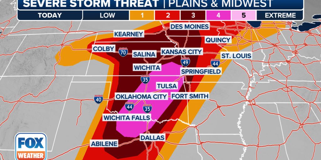
The greatest threat for a tornado outbreak Saturday stretches from north Texas into Oklahoma and southeastern Kansas, where NOAA’s Storm Prediction Center has issued a Level 4 out of 5 severe weather risk.
THE 5-POINT SEVERE THUNDERSTORM RISK CATEGORY SCALE EXPLAINED
Storms have the potential for long-track, intense tornadoes of EF-3 strength or greater, massive softball-sized hail stones and wind gusts over 75 mph.
Later Saturday evening, a line of severe thunderstorms is expected to form and move east across eastern Oklahoma and north Texas. The most intense parts of the storm line, which will last into the overnight hours, could produce embedded tornadoes and damaging wind gusts over 70 mph.
“This is going to be a very dangerous day for so many people, especially if you live in southeastern Kansas, eastern and central Oklahoma, and right into north Texas just across the Red River,” said FOX Weather Meteorologist Kendall Smith.
NWS Omaha credits residents for heeding warnings during damaging tornado outbreak
Despite strong tornadoes that caused extensive damage across some cities near Omaha and western Iowa, there were no fatalities, says Chris Franks with NWS Omaha.
NIGHTTIME TORNADOES: HOW YOU CAN STAY SAFE FROM NOCTURNAL TWISTERS
Severe weather threat extends north into Great Lakes
Meanwhile, a warm front to the north is likely to extend from Nebraska through Wisconsin, according to the FOX Forecast Center. This front will focus on a separate area of strong to severe storms on Saturday.
WHAT IS A ‘TORNADO EMERGENCY’?
Dangerous Level 3 severe weather risks spread across much of the Central Plains, including Kansas City, Missouri; Des Moines, Iowa; and Topeka, Kansas.
Both the Omaha, Nebraska, and Minden, Iowa areas that took direct hits from tornadoes on Friday are under a Level 2 severe weather risk on Saturday.
Once again, tornadoes and massive golf-ball-sized hail will be the greatest threats with these storms. Strong tornadoes of EF-2 strength or greater will be possible across southern Nebraska, eastern Kansas, and far western Missouri, including Kansas City and Topeka.
HOW DOES A TORNADO OUTBREAK HAPPEN?
The severe risk reaches north into the Great Lakes, encompassing swaths of Michigan, Illinois and southern Wisconsin, including Chicago and Milwaukee, which are also under a Level 2 risk on Saturday.
More daunting weather news: Major flash flooding now likely in severe weather outbreak zone
If tornadoes, hail and wind were not enough, much of the Southern Plains is also at a significant risk of flash flooding from Saturday into Saturday night.
WHAT ARE TRAINING THUNDERSTORMS, AND WHY ARE THEY SO DANGEROUS?
As the severe thunderstorms become more widespread on Saturday evening, some will be capable of producing heavy rain at the rate of 2-3 inches per hour.
Thunderstorms may be slow moves or stall, leading to multiple inches of rain to fall on the same areas and significant flooding.
NOAA’s Weather Prediction Center has now put parts of Oklahoma along the Interstate 40 corridor east of Oklahoma City at a Level 4 out of 4 flash flood risk into Sunday morning.
WHY RARE ‘HIGH RISK’ FLOOD DAYS NEED TO BE TAKEN SERIOUSLY
“Confidence continues to be high in a major flash flood event unfolding for portions of east-central Oklahoma with higher end rainfall totals Saturday beginning late evening into Saturday night,” forecasters with WPC wrote in 11 am CT forecast update.
24-hour rainfall totals in the Level 4 flash flooding risk zone may approach or exceed 10 inches, forecasters said. But even 3-6 inches or more and flash flooding is expected from the Red River Valley into much of Oklahoma, including Oklahoma City and Tulsa.
“High” risks for flash flooding are only issued on about 4% of days (including tropical and non-tropical events), but this risk category accounts for 39% of flood-related fatalities and 83% of flood-related damages on the continental shelf. US, according to https://twitter.com/AlexJLamers/status/1034528775680217090. What’s more, 46% of high-risk flood days have at least one fatality or injury, and 62% of such days have at least $1 million in damages, Greg Carbinforecast operations branch chief at the WPC, noted in the investigation.
More thunderstorms in the same area are possible on Sunday.
No rest for the weary: More severe weather expected Sunday
The severe weather threat is expected to wane a little for Sunday, but still presents a widespread risk of additional storms across the Mississippi Valley. A Level 2 severe weather threat covers over 20 million people from Austin and Dallas in Texas to southeastern Iowa and western Illinois.
Once again, tornadoes, large hail and damaging wind gusts are all in play, but the storms are not expected to be as intense as Saturday.
The nation’s heartland should finally be reprieved from severe weather on Monday.


