


We are in the prelude to a winter that should mark a significant change in meteorological terms. We have seen how June has increased the amounts of accumulated precipitation, especially in the central and southern areas of the country, and with this information, curiosity immediately grows to know what is going to happen in the following months of the season.
Previously, at Meteored, we had made a forecast of what winter 2024 would be like, but our ECMWF reference model has been updated, showing some changes in monthly patterns. Below, we give you the highlights of the forecast for this season.
A drier winter than usual
Today we are in a neutral phase; However, we can still perceive signs of what the coupling of the atmosphere to a warmer than normal ocean, during the El Niño season, which we can reflect in a quite rainy junewhich has recorded historical data, all of this also associated with the constant transit of frontal systems and the large contribution of water vapor that atmospheric rivers have added.
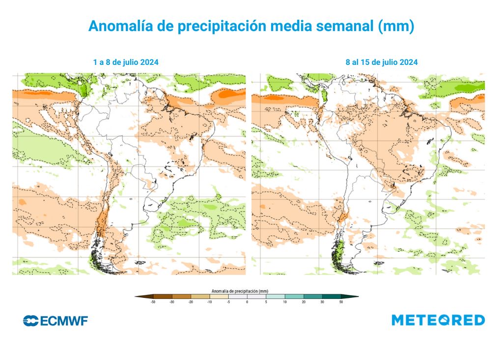
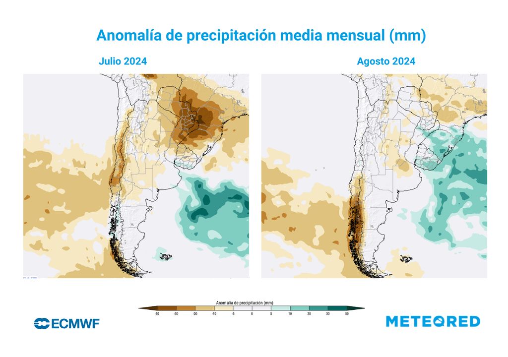
However, we will change the forecast, since according to the model, the season would not continue to be rainy. The month of July would begin with below normal rainfall In a large part of the country.
If we look at the first fortnight, it is expected that only the southern section of Patagonia could have rainfall above normal and it is appreciated a significant deficit of rain in the central and southern areas, therefore, everything indicates that we will begin an astronomical winter with little rainfall.
| City | Normal precipitation range July (mm) | Normal August precipitation range (mm) | JJA minimum temperature (°C) | JJA maximum temperature (°C) |
|---|---|---|---|---|
| The Serena | 2 to 17 | 0 to 15 | 7 to 8 | 15 to 16 |
| Valparaiso | 31 to 81 | 24 to 83 | 9 to 10 | 15 to 16 |
| Santiago | 30 to 54 | 19 to 50 | 4 to 5 | 16 to 17 |
| Talca | 69 to 126 | 47 to 102 | 4 to 5 | 13 to 14 |
| Chillan | 88 to 170 | 79 to 144 | 3 to 4 | 12 to 13 |
| Temuco | 114 to 198 | 104 to 148 | 3 to 4 | 12 to 13 |
| Valdivia | 210 to 301 | 178 to 260 | 4 to 5 | 11 to 12 |
| Montt port | 132 to 213 | 150 to 197 | 3 to 4 | 10 to 11 |
| Coyhaique | 80 to 139 | 80 to 126 | 0 to 1 | 6 to 7 |
| Punta Arenas | 19 to 33 | 19 to 33 | -1 to 0 | 4 to 5 |
| Normal ranges (1991-2020) of water fall (mm) for July and August and temperatures (°C) for June, July and August. This table allows you to compare the prognosis of anomalies, low, normal or above normal. Source: Meteorological Directorate of Chile. | ||||
However, if we analyze what the forecast says for the month of July in general, we can see that, above-average rainfall disappears and a period of dryness stands out in the section where the rainfall was concentrated in June. We can also highlight that, in the northern area, we can see normal to slightly below normal conditions for the time, just like Patagonia.
The projection for August indicates that a large part of the country would register normal rainfall, such as the northern area and part of the central area.
However, it is expected below normal rainfall in the interior from Maule to Biobío, while, from La Araucanía to Patagonia, there are also plans rains below the climatological average.
Although the conditions predicted for these winter months in the country reflect less rainfall than normal, It is important to follow the updates of the short-term forecast, since new episodes are not ruled out that can generate abundant rainfall.
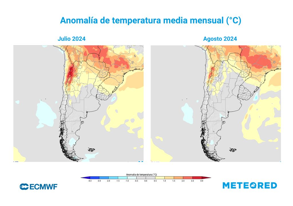
Normal temperatures will predominate in Chile
The seasonal winter forecast reflects quite atypical conditions in the northern part of the country due to twarmer than normal temperatures, so both July and August would have temperatures above average, mainly in mountain sectors from Arica to Atacama.
As we have seen, the month of June in particular has had temperatures above normal mainly in the northern area, although they have also spread throughout the central north.
During the month of July, something similar is seen in the north, with temperatures above normal from Arica to approximately the Metropolitan Region, showing an increase in the foothills and mountain ranges of Antofagasta, Atacama and the north of Coquimbo. It is also appreciated that the north and central coast could present normal temperatures for the seasonjust like Patagonia.
Regarding August, temperatures are expected to They will continue to be warm in the northern zone, especially inside; However, these would be less intense than the months of June and July. the rest of the country will be under normal conditions.


