

A month ends with extreme variability in temperatures in the country. We will tell you which areas of Buenos Aires may experience snow and hail in the next few hours, and to what extent the frost will extend.
It is culminating a extreme month of June in terms of temperatures in Argentinawith striking variability both spatially and temporally.
Let us remember that The first 20 days or so were characterized by very cold but concentrated in a small portion of the country which encompassed Santa Cruz and Tierra del Fuego, while the entire great rest of the country had Temperatures well above normal, which have even managed to break several historical records for the month.
But the circulation pattern changed in these last 10 days of the month, and low temperatures took over the entire national territorymaintaining a significant ferocity in the southern Patagonian portion with extreme marks and events with large accumulation of snow.
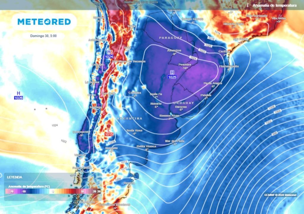
Now comes a weekend in which low temperatures will be reinforced that have already been occurring in recent days in the center and north of the country, due to the entry of a pulse of cold air of polar origin.
Thursday with temporary temperature rise and Zonda wind alert
This Thursday has been showing a temporary thermal jump in much of the country, prior to the outbreak of polar cold that will arrive in the next few hours. The high pressures have moved on the surface towards the north of the coast, and this has promoted a sudden intensification of the north-northwest wind in the center and north of Argentina that promotes the rise in temperatures.
This Thursday is probably the least cold day of the entire week in central and northern Argentina, a “hinge” that separates what was the cold influx of days ago, and the polar cold that will arrive as reinforcement starting tomorrow.
In terms of alerts, the prefrontal situation stands out, which will promote intense winds in the central-west of Argentina this Thursday, especially in relation to the probability of Zonda wind over the south of Mendoza where an orange level alert is in force due to the chance of gusts exceeding 100 km/hThe westerly wind will also be felt strongly in northern Patagonia and La Pampa.
Another consequence of this prefrontal situation with marked northwesterly winds was the intense downturn that occurred in the morning hours in the estuary of the Río de la Plataone of the most important of the few that there has been so far this year, with records of up to almost -1 meter in the Port of Buenos Aires. The situation was already beginning to normalize quickly since the afternoon.
The polar cold arrives, with probable snowfall and hail in the southeast of the province of Buenos Aires
The cold polar air will begin to enter strongly starting this Thursday night in the Pampean region, accentuating the thermal drop with strong southerly winds with gusts throughout Fridayand also progressively reaching the northern part of the country.
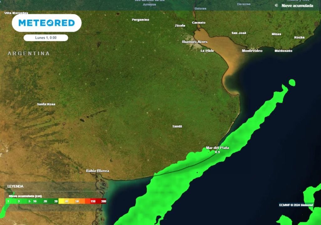
As we anticipated in Meteored, The chance of snow remains in the southeast of the province of Buenos Aires, especially in mountain areas such as Balcarce and Sierra de los Padres between Friday night and Saturday morning.
The coastline, mainly between Mar del Plata and Necochea, is more prone to showers, which could be small hail. between Friday afternoon and Saturday afternoon, with a lower but not zero probability of snow.
There will be mostly clear skies on Saturday across much of the country but despite this, The cold will be felt strongly all day, with low thermal sensation due to the effect of the south wind.
By Sunday, morning frosts will be widespread in central and northeastern Argentina, in one of the coldest mornings that 2024 will have without a doubt.. As a striking fact, negative temperatures will also cover the Eastern Republic of Uruguay, and even southern Brazil.
We keep you informed, stay connected with Meteored Argentina.