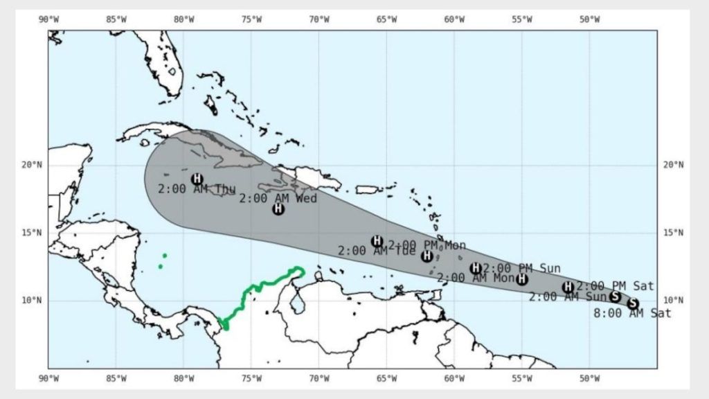
Image showing what the hurricane’s path could be like.
Photo: Taken from Ideam
According to the latest report from Ideam, Tropical Storm Beryl, which formed in the Atlantic Ocean, could become a hurricane this Sunday, June 30, or on Monday, July 1, in the early hours of the morning.
According to the statement, Beryl is expected to strengthen into a hurricane when it reaches the Windward Islands, located in the Caribbean, near Venezuela and Aruba and Curacao. At the moment, maximum winds of 93 kilometers per hour have been detected and its speed is 33 kilometers per hour.
Although there is still uncertainty about its route, the closest approach to Colombian territory, according to Ideam, could occur on Tuesday, July 2, or Wednesday, July 3.
For this reason, the institute issued a “vigilance” alert for all coastal sectors of the Colombian Caribbean region. These are: La Guajira, Magdalena, Atlántico, Bolívar, Sucre, Córdoba, Antioquia and Chocó. Also for the Archipelago of San Andrés, Providencia and Santa Catalina.
In this state of alert, three scenarios are being handled. One, in which there is no probability of the hurricane entering, but it can have an indirect influence. Another, in which there is probability of entry into the Caribbean Sea within the next seven days of its formation and may slightly affect the atmospheric conditions of the national territory. And one more, in which the ocean-atmospheric conditions allow to forecast a probability of cyclone formation between 30% and 50% within the Colombian basin within the next 72 hours. In this last case, it may affect the ocean conditions.
“Currently, a significant wave height of 1.0 to 1.9 meters is observed within the Caribbean Sea with winds from the east-northeast direction and an intensity of 10 to 22 knots,” says Ideam.
In its bulletin, the entity recalls that it has already activated the National Response Plan for Tropical Cyclones. In addition, it suggests keeping the protocols, contingency plans and all the actions for preparing for the response active.