


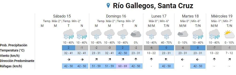
He National Metereological Service (SMN) prepared the weather forecast for this Sunday, June 16 in the city of Río Gallegos, and announced that a maximum temperature of 2° and a minimum of -3°C is expected.
In the early morning, the temperature in the capital of Santa Cruz will be -2°C. The wind will circulate from the Southwest, with speeds of between 23 and 31 km/h and gusts of up to 59 km/h. There is a 10-40% chance of snowfall.
In the morning, the temperature will be -3°C. The wind will blow in the Southwest direction, with a speed of up to 41 km/h and gusts of between 51 and 59 km/h. There is a 10-40% chance of snowfall.
In the afternoon, the temperature will be 2°C. The wind will circulate in a southwest direction, with speeds of between 42 and 50 km/h and gusts of up to 69 km/h. There is a 10-40% chance of snowfall.
At night the thermometer will read -2°C. Winds will range between 23 and 31 km/h, heading south, with gusts of up to 50 km/h.
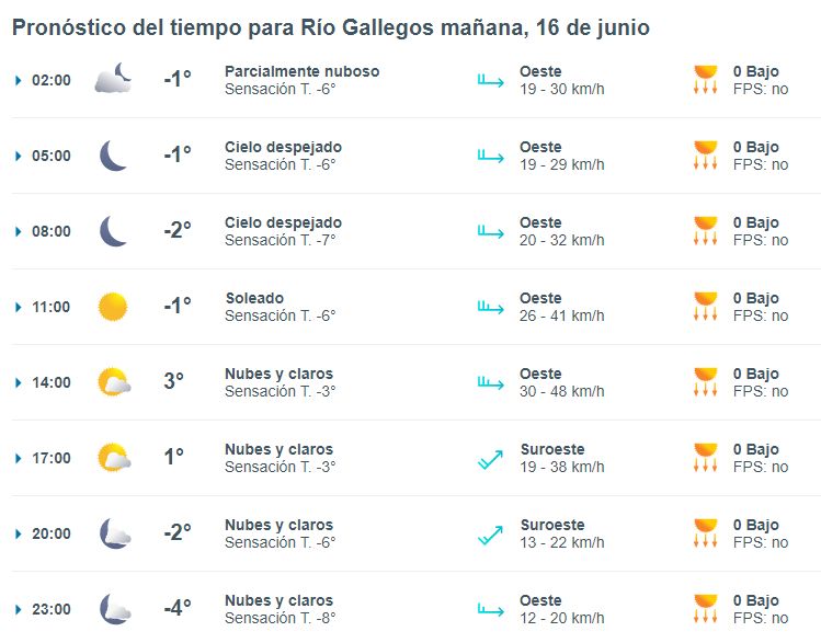
Weather Forecast in Río Gallegos: what Meteored says
The table highlights that the maximum temperature will be 3°C at 2:00 p.m. The lowest thermal sensation due to the effect of wind and humidity will be -8º at 11:00 p.m.
While the most intense gusts would reach 48 km/h at 2:00 p.m.
The UV index will remain at 0 throughout the day, so it is not suggested to use a Sun Protection Factor.

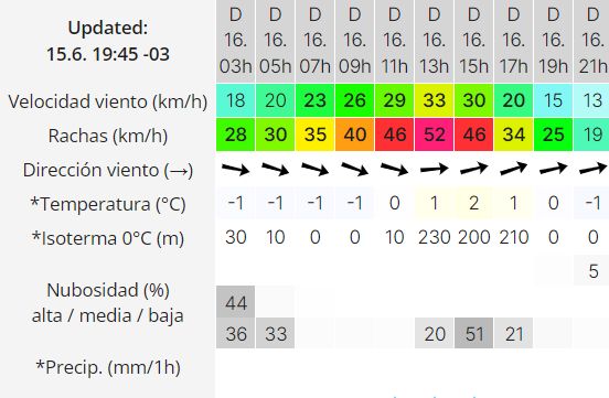
Weather Forecast in Río Gallegos: what Meteored says
This service indicates that the maximum temperature will be 2° at 3:00 p.m. Meanwhile, the highest intensity gusts will reach 52 km/h at 1:00 p.m.

They issued an early warning for heavy snowfall in Santa Cruz
The Undersecretary of Civil Protection and Comprehensive Approach to Emergencies and Catastrophes shared an early alert issued by the National Metereological Service (SMN) due to intense snowfall in Santa Cruz.
“In the afternoon of Monday, 06/17, the area will be affected by persistent snowfall of varying intensity,” the agency’s statement said.

He also explained that “accumulated snow values between 20 and 30 cm are expected, which may be exceeded from time to time. It is not ruled out that in the lower areas precipitation may occur in the form of rain or sleet,” he added.

According to the extended forecast issued by the SMN, snowfall is expected from this Saturday afternoon until Wednesday. with very low temperatures that will range between 0 degrees maximum and -6 degrees minimum.
The wind in Santa Cruz now live and direct
Weather in Santa Cruz
The predominant climate of the area is Patagonian semi-desert, cold, dry, with constant winds from the Pacific.
However, two types of climate coexist in the province of Santa Cruz: the arid Patagonian climate of the center and east and the cold humid climate of the west. In a thin strip that extends from north to south along the Patagonian mountain range, the cold humid climate prevails. Pacific influence regarding the production of rain and snow.
The typical feature of climate more distinctive for most of the province of Santa Cruz It is the almost constant blow of winds coming from the Pacific Ocean.
The influence of this cold humid climate does not exceed 50 kilometers from the international border with Chile, making the contrast evident with respect to the climate typical of the plateau. The rains are autumn and winter. He Patagonian arid climateis characterized by having annual temperatures between 5 and 10 °C, ranging in January from 12 to 20 °C and in July from -15 to -7 °C.

The precipitation They decrease from west to east, making noticeable the landscape contrast between the rainy mountainous region to the west and the plateau of reduced rainfall. Wind blowing from the west, northwest and southwest, it is a true protagonist that erodes everything in its path. On the central plateau, rainfall is low: it varies between 150 and 200 mm annually.
The snowfall They are frequent throughout the province, being greater in the west near the Mountain range than in the east near the coast, but in general it is common to see snow throughout the province, especially in winter.
Santa Cruz Ecosystem
In general, the climate of the region is arid and cold with very low temperatures almost all year round and strong thermal amplitudes and insufficient rainfall, determining the semi-desert biomewhere hard steppe and tusac grasses predominate such as neneo, coiron and adesmias as the Adesmia campestri and the Adesmia volckmanni. Although the basin area of the Santa Cruz River In its extra-Andean region it is favored by a mild climate thanks to the strong oceanic influence, this is the region of the so-called Pampas of Dianatowards the Andean foothills and foothills, humidity is also important, to the extent of favoring the existence of forests, corresponding to the cold Magellanic forest of fagaceae and conifers (lenga, cohiue, ñiré, canelo, mañiú, fir the latter, allochthonous), although due to the altitudes, the humid mountain range, with an average annual rainfall of 800 mm, is cold almost all year round.
Weather in Patagonia
He Patagonian climate It is located in the moderate type, with four well-defined seasons, with short springs and autumns and long winter, and great amplitude between winter and summer temperatures. A cross section shows annual thermal amplitudes of more than 10° in San Carlos de Barilochemore than 17° in Maquinchaoin the heart of the Meseta, and about 13° in Carmen de Patagones, 30 km from the Atlantic. Due to its height, the area of Maquinchao (about 800 m above sea level) exceptionally reaches 30° below zero, making it as cold as the coldest areas of the Southern Patagonia. The average temperature in winter, however, is -2°, the same as in the Tierra del Fuego Argentina. The maximum temperatures Absolute temperatures are high in Patagonia, with marks of up to 45° in the eastern part of Mesopotamia configured by the Colorado and Black rivers, and a little less in Carmen de Patagones. In Maquinchao they can exceed 35°, while they reach 30° in Ushuaia.
To the south of the 30°S parallel, the westerly winds become dominant, abandoning their load of moisture from the Pacific in the mountain range: rainfall increases from 2,000 mm to 5,000 mm on the western slope (Chile), to 600 and 400 mm of precipitation in the east (Argentina). In the extra-Andean region, the zone of maximum dryness, formed by the isohyet of 200 mm of precipitation, starts from the middle portion of the Colorado River and extends southward to cover the entire length to the Strait of Magellan. Humidity increases in the northeast corner and towards the north of the area, as well as towards the west, where it reaches up to 400 mm in the southern portion of the Cordillera -500 mm and more in Tierra del Fuego-, and 800 and up 1,000 mm of precipitation in high areas of the northern portion.


