


The cold front of the frontal system that is moving over the southern part of our country will manifest itself with all its power during the next few hours, affecting precipitation that will not give rest yet.
The next few days will be marked by meteorological frosts in the Magallanes Region due to the incursion of a high pressure with cold characteristics.
As a consequence of this atmospheric scenario, the Chilean Meteorological Directorate (DMC) has maintained the alert for moderate to intense frosts that are capable of forming ice. Its validity extends until the early hours of this Friday the 21st, the day in which they are projected minimum temperatures between -12 °C and -8 °C.
In addition to this, the DMC issued an alert for moderate to heavy rainfall -from the Valparaíso Region to the Ñuble Region- which will be in force until the morning of Saturday the 22nd, which originates from the displacement of the current frontal system over central Chile.
The highest amounts of water fall are expected for Friday, a day in which some 60 mm on the coast of the Valparaíso Region and 65 to 70 mm in the foothills of the Metropolitan Region and the O’Higgins Region.
Likewise, the height of the snow will take center stage in the Andes mountain range of the O’Higgins Region, since only on Friday could register 110 cm.
Frontal system will arrive in full force in northern central Chile on this day of the weekend
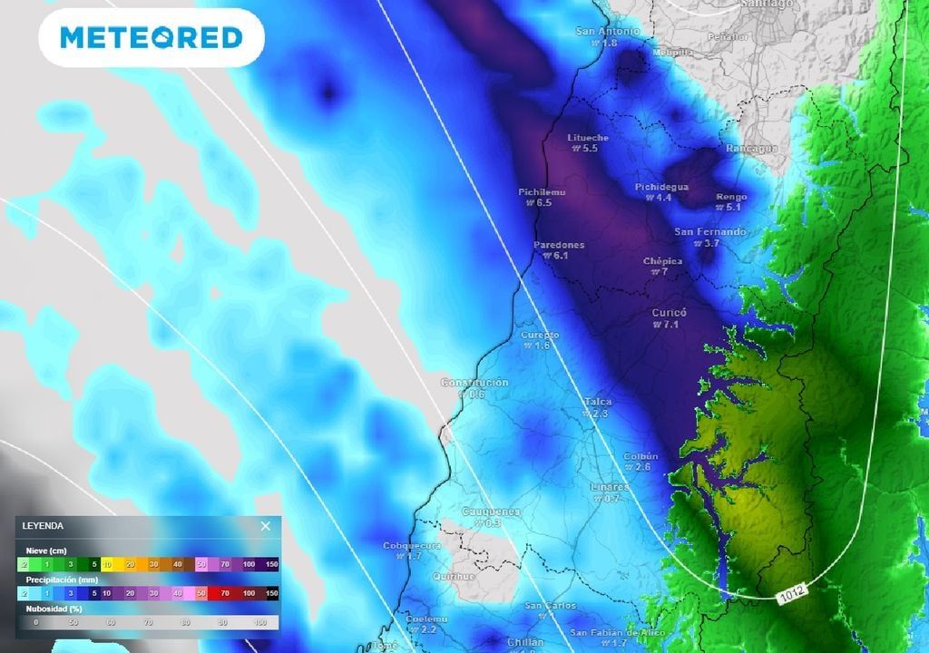
To finish the day this Thursday the 20th, and considering the analysis of our reference model, precipitation will be concentrated between regions of O’Higgins and Aysén.
It is important to mention that, as seen in the following image, the rains will be extremely heavy on the dark diagonal line that covers the regions of O’Higgins and Maule.
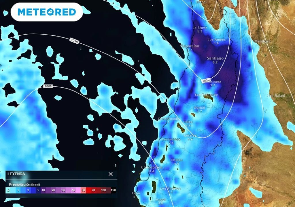
As the hours pass, The cloud band of the cold front will continue to advance northward, waking up on Friday with intense rainfall at western sector of the Metropolitan Region and the coast of the Valparaíso Region.
Showers will also be present in the southern regions with significant pulses during Friday afternoon in the regions of O’Higgins and Maule, while in the valleys and foothills of the Valparaíso Region “they will throw it away with a bucket” after lunch time.
Such will be the intensity of this frontal system, that will be able to bring precipitation to the Coquimbo Region, mainly to Los Vilos, Illapel, Salamanca and Punitaqui in the hours of Friday night.
The electric storms They will be highlighted during Friday in the Biobío Region.
The end of this week It will also be crowned by snowfall on the Andes mountain range, which will be distributed from the Coquimbo Region to the Aysén Region.
It is worth mentioning that between the northern limit of the aforementioned geographic section and the Biobío Region, wind gusts that could exceed 80 km/h.
Attention! On Saturday, pulses of rain will persist in these regions of the central zone
Snowfall will remain during the Saturday day this weekend from the Coquimbo Region to the Biobío Region with Wind gusts around 60 km/h.
Between the regions of La Araucanía and Aysén, the meteorological scenario over the Andes mountain range will weaken to snow showers.
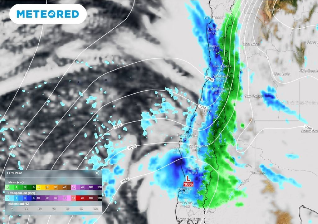
In the early hours of the morning and on Saturday morning Liquid precipitation will cover a large part of the Coquimbo Region, while from the Valparaíso Region to Los Ríos Local pulses of intense rain are expected.
After lunch on Saturday, the rains will weaken in much of central and southern Chile, except in the regions of Ñuble, Biobío and La Araucanía where they will persist local showers until early Sunday morning.
A new atmospheric scenario arrives that will make us take out vests, coats, hats and more
On Sunday, snowfall will be light over the Andes mountain range between Coquimbo and Biobío, which will be accompanied by gusts of wind that will oscillate between 40 and 50 km/h.
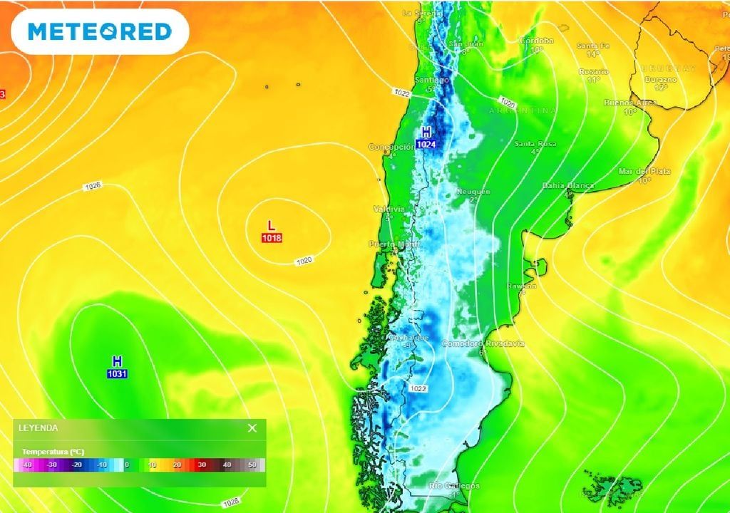
With the withdrawal of the frontal system, another atmospheric friend arrives this Sunday: a high pressure of cold characteristics. The new meteorological scenario will cause a drop in thermometers, mainly from the Valparaíso Region to the Magallanes Region.
Sunday minimum temperature is projected between 3 °C and 5 °C in the valleys and the foothills of the central zone. In the south, the decrease in this meteorological variable will be more noticeable, since in places like Coyhaique Sunday morning It will be around 6 °C below zero.
Sources and references of the news:
– Meteorological Directorate of Chile. Alerts AA48-1/2024; AA50/2024.


