The country is still recovering from the heavy rains caused by the current frontal system, which included an atmospheric river during the evening of Tuesday the 25th. This phenomenon has led to the overflowing of several rivers and estuaries in the La Araucanía Region.
SENAPRED has issued several yellow alerts along with two active red alerts: one for the provinces of Cautín and Freire due to the overflowing of the Pelales estuary, which has caused flooding in homes and land; The second red alert is in force due to the increase in the flow of the Mahuidanche River in Santa Ana, which has put the commune of Pitrufquén on maximum alert due to the risk of possible overflows and the associated potential damage.
A cold air mass is expected for this Friday 28th, which will cause frost in the southern zone. The reference model indicates that a new system is approaching, accompanied once again by a river of water vapor moving through the atmosphere.
The frontal system and the atmospheric river are associated with a high zero isotherm
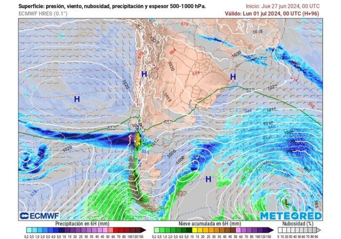
The main low pressure of a frontal system will reach Patagonia on Saturday 29th and then it will advance rapidly towards the south of the country, where the first rains are expected to occur during the early hours of Sunday 30th in sectors of Los Lagos and Los Ríos.
On Sunday, the frontal system will move from the Los Ríos Region towards La Araucanía, where significant rainfall accumulations are expected.
During that day, The zero degree isotherm will be located between 2,000 and 2,500 meters above the Los Ríos Regioncoinciding with the peak of rainfall in that area of the country.
The frontal system will enter this area with a high zero isotherm, which means that the precipitation will be mostly liquid, in the form of heavy rain and showers.
The zero degree isotherm is an atmospheric boundary defined that varies in height depending on the interaction of various air masses at a given location.
This level marks the transition between solid precipitation (above the zero isotherm) and liquid (below this level).
This region, already affected for several weeks by intense and successive rains, Its soils are waterlogged and saturated due to the excess rainfall received. This causes the current rains to flow superficially, causing a rapid increase in the flow in rivers, estuaries and other bodies of water in the area.
Heavy rain in a short period of time
The advance of the frontal system, now associated with the atmospheric river, will result in heavy rains concentrated in a few hours. Heavy showers are expected during Sunday in areas of Los Lagos and Los Ríos, as the frontal system moves towards the Araucanía Region.
According to the ECMWF model estimates, Showers could accumulate more than 8 mm per hour in sectors of the coastal mountain range mentioned above.
Between Sunday night and early Monday morning, July 1, the frontal system is expected to generate intense rainfall. in some areas of the Araucanía foothills. Rainfall accumulations of between 35 and 55 mm are expected in the area around Pucón during this period.
To what region will the frontal system advance?
The effects of this frontal system could extend to the Ñuble Region early next week. In the Biobío Region, closer to central-southern Chile, lower intensity precipitation is expected due to the advance of the frontal system.
Find out if rainfall will reach the central north
Currently, high pressures will predominate in the center-north of the country, which will prevent the advance of frontal systems towards that area of the national territory.
According to information from ECMWF models, the first week of July will be characterized by the absence of precipitation. in the regions of Valparaíso, Metropolitana and O’Higgins. Much of the Maule Region will also experience a drier period in the coming days.