After the dazzling sunshine with a temperature exceeding 40 ° C, on 10/5, Northern and North Central Coast inspired rain and thunderstorms on a large, local heavy raining over 150mm.
The North and the Central region are about to welcome the cold air, causing heavy rain and strong thunderstorms, closing the hot, hot days lasting on a large scale. Today’s forecast (May 9) will be the last hot day in this batch.
Around 10/5, cold air affects some places in the Northeastern mountains. Around the evening and night of 10/5, the cold air was stronger, affecting other places in the Northeast, then to the North Central, the Northwest and some places in Central Central.
From the night of 10/5, the North and the North Central of the sky turned cool, the Northern mountains were cold. The lowest temperature in this cold air in the North and North Central Coast is popular 20-23 ° C, the high mountains have places below 18 ° C.
The influence of cold air compresses low pressure grooves, evening and night 9/5, Northern and Thanh Hoa showers and scattered thunderstorms. Rain will help cool down after days hot weather, but also have the potential risk of natural disasters due to heavy rainfall concentrated in a short time.
The common rainfall forecasts during this period of 15-30mm, some places can record rainfall exceeding 60mm.
In the next 6 hours, the risk of flash floods, landslides, and land subsidence on the slope and small streams in Vi Xuyen, Bac Quang, Hoang Su Phi and Quang Binh districts of Ha Giang province.
-The peak of heavy rains on a large scale is likely to occur day and night 10/5, lasting until the morning of 11/5. Rain will appear on a large scale in the North and North Central Coast, which is concentrated in mountains, midlands and plains.
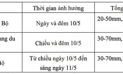
Accordingly, day and night 10/5, the Northern mountainous region has moderate rain, heavy rain, locally where there is very heavy rain and thunderstorms, the common rainfall of 20-50mm, some places over 100mm. From the afternoon and night of the same day, the plains and the Northern Midlands also catch moderate rain, heavy rain, local rain very heavy and thunderstorms with greater intensity, rainfall from 30-70mm, some places over 150mm.
In the North Central Coast, from the afternoon of 10/5 to the morning of 11/5 will appear moderate rain, heavy rain, locally where it is very heavy and thunderstorms, the forecast rainfall fluctuate 30-70mm, some places over 150mm.
It is worth noting that these heavy rains occur in a short period of time, rainfall can reach over 80mm in just 6 hours. This increases the risk of extreme weather phenomena such as flooding in low -lying areas, urban areas and industrial parks; flash floods on small rivers and streams; landslides in hillside with steep terrain.
In thunderstorms, extreme weather phenomena are likely to occur like whirlwinds, lightning, hail and strong winds.
From 11/5, heavy rain in areas tends to decrease.


