
If the week has been radiant, this weekend may be more unstable, with the return of a few showers and thunderstorms in a major part of the country and a significant drop in temperatures. Mercury will drop by more than 10 ° C in two days over the northern half of the country.
The good weather of this week does not seem to be renewing itself for this weekend. If the sun has traveled all hexagon from Monday, April 28 to Friday, May 2, with heat, with the heat of 30 ° C in the northern half of the country, Saturday and Sunday will be marked by more unstable weather, with a drop in temperatures up to 10 ° C on the northern part.
“It is a radical change of time waiting for you,” warns the weather channel. “After a Saturday still summer but heavy and becoming stormy, time will become disturbed on Sunday with rains, showers and frequent thunderstorms”, on a large part of France.
Friday: hot weather with some thunderstorms
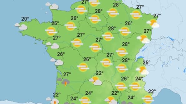
While waiting for the arrival of bad weather, it will be necessary to take advantage of this Friday, which aligns with the temperatures of the day before, with sun but no more clouds. The morning will remain hot, like the previous days, with temperatures oscillating between 16 ° C and 24 ° C throughout the territory.
A heat peak is notably expected in the second half of the day: Météo France provides up to 28 ° C in the northern half of the country, notably in Paris, Reims or Auxerre, with an average of around 25 ° C throughout France.
It was not until the start of the evening that time is spoiling. “The first signs of degradation will appear in the evening in the southwest, especially in Aquitaine,” said the weather site.
If the thunderstorms are not necessarily generalized, they can locally be intense with great instability conducive to gusts of wind, intense and locally hail, “said the weather chain.
Saturday: an unstable time expected
Because of a depressional hollow, called “thalweg” linked to the cold air downhill from the north, the heat will gradually disappear with an increasingly unstable time.

“The thunderstorms will gain ground towards the center of the country, then towards the northeast ‘, says weather forecast. Storms at the level of the plains and reliefs. Only the Southeast will remain spared thunderstorms and showers.
In the afternoon, Météo-France plans 19 ° C in Lille, 25 ° C in Bordeaux and in Lyon, or 20 ° C in Nice, Montpellier, Biarritz and Brest.
Sunday: dropping of temperatures
“It is Sunday that the degradation will reach its peak of intensity. Thunderstorms will concern most of the country,” announces the weather chain, specifying that the cooling of temperatures “will occur by the north of the Seine, with a gradual return of a fresher and stable air by Hauts-de-France”.

Météo France provides an average of around 15 ° C in the morning. The degrees decrease drastically in the afternoon, compared to the previous days: it will be around 16 ° C over the northern half of France and up to 20 ° C to the south, notably in Marseille, Nice and Ajaccio.
However, the next few weeks seem to be more stable: “the bridges could be generally pleasant,” predicts the weather channel, adding that “thunderstorms will tend to wedge especially in the south”.


