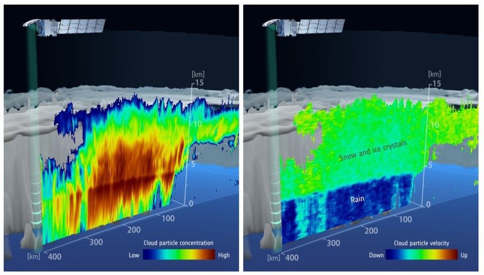
Less than a month after its launch, ESA’s EarthCARE satellite has sent back the first image from space showing the internal structure and dynamics of clouds.
Taken with profiling radar provided by JAXA, Japan’s space agency, this first image is shown above in two parts. On the left, the data reveal the vertical concentration of cloud particles measured as radar reflectivity. It is clear to see that the densest part of the cloud is at its center, where there are more large particles and the particles are large.
On the right, we see the falling speed of the cloud particles. Low values in the upper layer indicate ice crystals and snowflakes that are suspended or slowly falling. In the lower layer, much higher values of fall speed indicate rain, the ESA reports.
Both images show a clear boundary at an altitude of about 5 km, which is where ice and snow melt, forming water droplets that fall as rain.
Cloud profiling radar uses its Doppler velocity capability to measure the vertical speed of movement of ice, snow, and rain.
This detailed information on the density, size distribution and speed of particles allows scientists to distinguish the components of clouds and therefore better understand their physics.
Thanks to EarthCARE, this is the first time this measurement has been provided from space.
EarthCARE carries four sophisticated instruments that have been designed to work in harmony to shed new light on the role that clouds and aerosols play in warming and cooling Earth’s atmosphere, thereby contributing to a better understanding of climate change. , snow and rain.
This detailed information on the density, size distribution and speed of particles allows scientists to distinguish the components of clouds and therefore better understand their physics.
Thanks to EarthCARE, this is the first time this measurement has been provided from space.
To give some context to these first results, the image on the right shows the same cloud system captured by the Japanese weather satellite Himawari-9 in geostationary orbit, about 36,000 kilometers above Earth. The image has been overlaid with EarthCARE’s orbital path.
The two images below show the vertically resolved cloud particle concentration, measured in radar reflectivity, and the vertically resolved velocity of cloud particles from EarthCARE Cloud Profile Radar data between markers A and B on the Himawari-9 image.
Conventionally, this data can only be obtained using ground-based or aircraft-based cloud radars. These methods can only measure limited areas, but the cloud profiling radar on board the EarthCARE satellite makes it possible to measure cloud structure uniformly across the planet.


