


The persistence of wind from the northern sector caused a resounding change in general conditions, from the increase in thermal marks in most of Argentina, as well as the increased humidity.
This situation is being reflected by the significant presence of fog in large sectors of the center of the country. Areas in which visibility is zero or less than 100 mso you have to take extreme precautions.
But finally, during the weekend it is expected that the high moisture content also generate conditions of instability and cause the development of rains and storms of varying intensity over the province of Buenos Aires.
Warning for possible strong storms
He National Meteorological Service has already issued a yellow alert for probable strong to very strong storms for the center and south of the province of Buenos Aires, east of La Pampa and east of Río Negro.
In addition to the storms, they are expected to be associated with significant gusts of wind that will affect the region, so the events will not only be limited to rainfall but also to the strong presence of wind.
The issuance of the alert is fundamentally based on the abundant water fall in short periods of timesince it is expected that they can register accumulated between 20 mm and 50 mm limited only to Sunday’s day.
It is also expected that Precipitation is associated with intense gusts of windstrong electrical activity and the occasional presence of hail in some specific sectors. All this activity will be limited especially to the first part of Sunday.
Alerts for snowfall and wind
Not only the Pampas region will be under alert during the weekend. All the mountain range of Cuyo and northwest Argentina will be affected by the presence of strong wind and snowfall of varying intensity.
From Jujuy to San Juanthe entire mountain range will be affected by very strong wind from the westwhich will remain from Saturday afternoon to Sunday night. Wind speeds are estimated that could reach 70 km/h with gusts that would exceed 100 km/h.
This situation will begin to strengthen from Saturday afternoon, but will reach highest intensity on Sunday morning.
Our maps confirm a cyclogenesis with storms this weekend in central Argentina
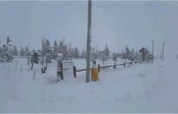
Notably, over the mountain range of Mendoza and Neuquénnot only will the wind be present, but also snowfall of varying intensity is expected. During the Saturday night It is expected that they will begin to register a increase in wind intensity that will accompany the snow fallgenerating a very significant reduction in visibility throughout the region.
It is expected that The situation begins to improve from Sunday nightwith the dissipation of snowfall and the decrease in wind intensity over the entire region.


