


The National Weather Service launched yellow and orange alerts for this Wednesday and Thursday throughout the mountain range in Neuquén and Río Negro. The Interjurisdictional Authority of Cuencas (AIC) reported that the situation is due to the entry of a new front system with rain and snowfall for the entire northern mountain range of Patagonia.
After the strong winds this Wednesday, accompanied by rain and snow. The alert is extended for this Thursday It once again affects the Río Negro and Neuquén mountain range, as well as the center of Neuquén. The detail by zones and times is as follows:
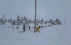
Rain and snow alert: what will happen in the Alto Valle
None of the alerts launched by the National Meteorological Service will reach the Upper Valley for the moment. Both in this area of Río Negro and Neuquén and on the plateau rise in temperature is expected. For the rest of the week, unstable periods will be combined with mild afternoons and wind with gusts.
Alert for rain and snowfall in Neuquén: the details
For the night of Wednesday and early Thursday morning the snowfall alert goes to orange level. The Affected areas are the mountain range of: Aluminé, Chos Malal, Loncopué, Minas, Picunches and Ñorquín.
The area will be affected by heavy and persistent snowfall. Accumulated snow values between 40 and 60 cm are expected, which may be exceeded occasionally. It is not ruled out that in the lower areas precipitation may occur in the form of rain or sleet.
For Wednesday night and early Thursday there is a yellow and orange alert for heavy rains in the zones from Catán Lil, Collón Curá, Zapala, east of Loncopué, east of Picunches, east of Ñorquín, west of Añelo, west of Pehuenches, south of Chos Malal, south of Mina, Huiliches mountain range, Lácar mountain range and south of Aluminé.
The greatest rainfall will occur in the early hours of Thursday, as there is an orange alert, and during midday and afternoon on Thursday.
According to the SMN, the area will be affected by heavy and persistent rains. Accumulated precipitation values are estimated between 30 and 70 mm in the alert period, which may be exceeded from time to time. In the highest areas, the occurrence of sleet is not ruled out.
Rain alert in Río Negro: the details
In the province of Río Negro the alert changed to yellow for this Thursday and will be due to intense rains. The affected areas will be Bariloche and surrounding areas.
The mountain area will be affected by persistent rains of moderate intensity, or locally strong. They are estimated accumulated precipitation values between 15 and 30 mm, which can be overcome in a timely manner. In the highest areas they could be in the form of snow.
Recommendations for yellow and orange alert for rain and snowfall
Yellow:
1- Avoid outdoor activities.
2- Don’t take out the trash. Remove objects that prevent water from draining.
3- Stay away from coastal and riverside areas.
4- Stay informed by the authorities. Always have an emergency backpack ready with a flashlight, radio, documents and telephone.
Orange:
1- Find a place indoors.
2- Stay away from coastal and riverside areas.
3- Cut off the electricity supply if you identify a risk of water entering your house.
4- Stay away from light poles or electricity cables.
5-In case you or someone else is affected by this phenomenon, contact local emergency agencies. Always have an emergency backpack ready
with flashlight, radio, documents and telephone.


