The data was shared by the UBA economist and CONICET scholarship holder, Paola Gevaerd, who is also a specialist in the impact of the Argentine productive structure on the environment and the regulations that protect them. And in the last hours she spread the images of the satellites of Argentina, the rest of the world and Neuquén.
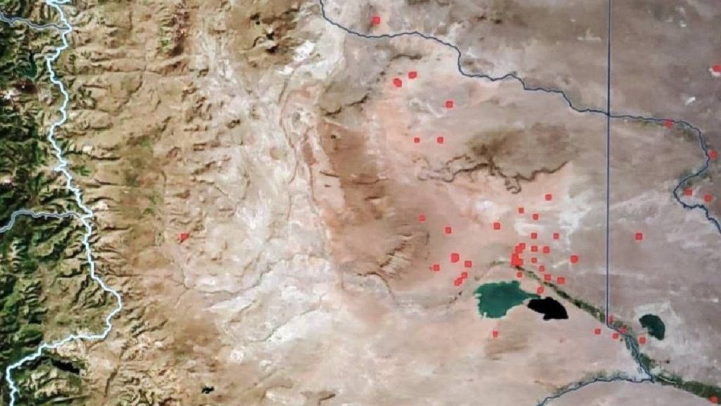
Map of fire alerts and hydrocarbon concessions.jpg
The white dots are the fire alerts in the hydrocarbon areas in green boxes, according to satellite data from the Global Forest Watch platform.
Fire alerts do not correspond to burned tree surfaceas can occur in the mountain range with forest fires, but with the rise in temperature or outbreaks, which are not necessarily related to natural disasters.
However, The satellite data draw attention, because the increase in the number of alerts rests on the hydrocarbon areas of Vaca Muerta, in the department of Añelo. The area is known to have high temperatures, especially in the five months of highest gas production.
Fire alerts: Is it gas venting?
There is also another heating stage at the Vaca Muerta facilities, in which the oil is associated with natural gas, which does not have the facilities to capture it and take it to a gas pipeline.. It is the “gas flare” that cannot be used due to the environmental impact it has.
According to the reported data, From the beginning of April until June 12, Neuquén had a total of 748 VIIRS (fire alerts), according to the Modis and Actis satellites. This is a real-time measurement and alerts can detect various sizes of fires, depending on temperature, day and the presence of clouds.
Fire alerts in Argentina and Neuquén.JPG
The increase in fire alerts in Neuquén is greater than that of the country from April to June of this year.
The data provided reveals that between April 1 and June 12, 2024, registrations in Neuquén “are unusually high compared to previous months and the same period in the rest of the country.”
However, what is striking is that, in June of last year, the satellite record would have presented similar values, being the months of greatest gas production. As is known, the gas business in Argentina lasts five months, from April to August. And it is precisely during this period that high temperatures are recorded in Vaca Muerta.
Production, gas and “heat” in Vaca muerte
According to the data managed by Geaverd, there is an overlap between the fire alert sources and the map of hydrocarbon concessions. And the two points with the greatest heat generation, conceptualized as a “fire alert” is in Fortín de Piedra (Tecpetrol), the largest shale gas field in Argentina and La Calera (Pluspetrol), with huge facilities.
Natural Gas _ Venteo.jpg
Natural gas vents are taken by satellites as sources of fire alerts.
Precisely last April, gas production in Neuqéun reached 92.3 million cubic meters per day (MMm³/d) with a year-on-year increase of 11%.
“This is added to the fact that 82 percent of the fire alert sources were concentrated in the department of Añelo, where most of the hydrocarbon concessions are located,” Geaverd told LM Neuquén.
What are VIIRS alerts?
Fire alerts issued by VIIRS (Visible Infrared Imaging Radiometer) are based on the identification of hot spots, that is, areas that show temperatures significantly higher than their surroundings, which suggests the presence of fires or controlled burning. These alerts are crucial for the early detection and monitoring of forest fires and other thermal activities, allowing a rapid and efficient response to minimize damage and risks.
In the context of Vaca Muerta, these alerts may be especially important due to industrial activity related to hydrocarbon extraction, where the presence of fires could have significant consequences for both safety and the environment.
The data in Argentina: loss of forests
Gevaerd highlighted the satellite data reported in Argentina, in a measurement days ago during the last four weeks. Neuquén was the region with the highest number of fires (alerts)“which represented 5.7% of all alerts detected in Argentina, and is unusually high compared to the same number of fires since 2012.”
The scientist also highlighted another aspect of the satellite measurements, outside of the alerts, which are the loss of tree cover due to fire, something that does not happen in Vaca Muerta, but does happen in other areas of the country, such as, for example, Chaco.
“In the last 10 years, forest fires caused 30% of the loss of tree cover worldwide. Argentina is among the 10 countries that presented the highest levels of tree cover loss due to fires“he indicated.
Thus, the satellites in the world that detect early warnings about fires capture the heat of Vaca Muerta, which is another strong piece of information that emerges from the activity.


