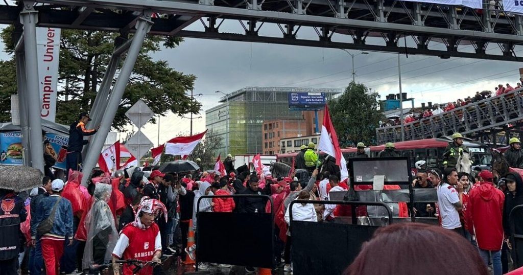
The grand final of Colombian soccer will be held this Saturday, June 15 and minutes before the game startsthere are already several mobility problems due to fans who are gathered in different areas of the city.
TransMilenio reported that there are delays and complications in the provision of the service in front of the El Campín stationboth in zonal and trunk services due to caravans and the presence of pedestrians in the sector.
“Due to an agglomeration of fans in the NQS at the height of the El Campín Stadium at the time the trunk fleet is stopped in CAD south – north and 7 de Agosto in the north – south direction,” the system indicated.
Road closures and detours per match between Santa Fe and Bucaramanga
At a time between 01:00 pm and 11:00 pm at the Nemesio Camacho El Campín Stadium, The District Mobility Secretariat has authorized the following road closures:
Authorized road closures
-
Transversal 28 between Calle 57 and Carrera 28:
- Total closure of the eastern and western carriageways.
- The platform on the eastern side will not be affected.
- The organizer must implement a controlled access lane for affected residents, using plastic briefcase-type barriers intertwined with tubular delineators and logistics personnel to instruct residents how to enter and exit the road section.
-
Calle 53B bis between Carrera 28 and Avenida NQS:
- Total closure of the north and south carriageways.
-
Calle 57A between Avenida NQS and Diagonal 61C:
- Total closure of the road.
- Access must be guaranteed to the parking lot in the northern area of the El Campín stadium, located between Av. NQS and Diagonal 61C.
- The organizer must coordinate the mitigation measures with those proposed for the activities at the Movistar Arena Coliseum.
-
Pedestrian path and cycle path on the eastern side of Av. NQS:
- They must not be affected and must be completely free.
Authorized diversions
-
Users traveling in the South – North direction on Av. NQS and wish to take Calle 53B Bis to the East and Carrera 24 to the North:
- They should continue north along Av. NQS, take Diagonal 61C to the East and then Av. Carrera 24 to the North, connecting with their usual route (See Map 1).
-
Users traveling in the South – North direction on Av. NQS and wish to take Calle 53B Bis to the East and Calle 57 to the East:
- You can take Calle 51 or Calle 53B to the East, then Carrera 27 and Transversal 27 to the North, to join Av. Carrera 24 to the North and continue with your usual route (See Map 1).
-
Users traveling in the South – North direction on Av. NQS and wish to take Calle 57A to the East:
- They should continue north along Av. NQS and then take Diagonal 61C to the East, connecting with their usual route (See Map 1).
-
Users traveling in a North – South direction on Av. Carrera 24 or Transversal 28 and wish to take Av. Calle 53 to the West:
- They must take Transversal 25 to the South, then Diagonal 53C to the East, continue along Carrera 24 to the South and join Av. Calle 53 to the West to continue with their usual route (See Map 2).
-
Users traveling in the East – West direction on Calle 57 and wish to take Transversal 28 and Carrera 28 to the South and Av. Calle 53 to the West:
- They must take Carrera 21 to the South and then Av. Calle 53 to the West to connect with their usual route.
#Colombia


