


The first frontal system is over the territory and will advance towards the central area in the next few hours. The week promises the arrival of another front between Wednesday and Thursday, accompanied by a new atmospheric river.
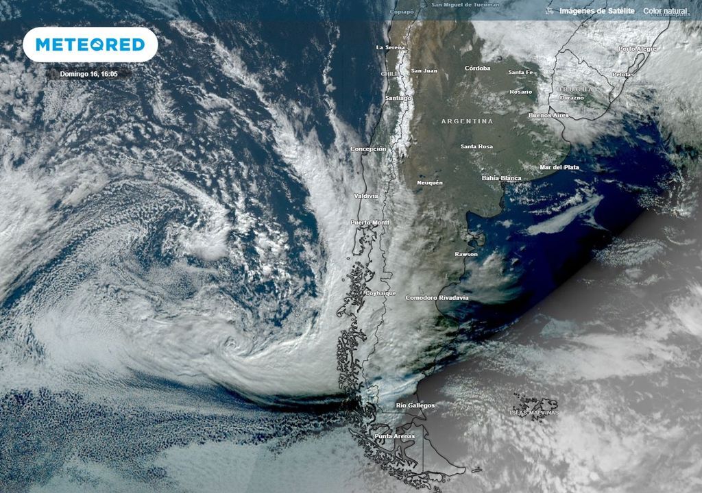
A rainy week ends badly and now More rainfall is heading towards Chilewhich will affect not only the south and Patagoniabut also They will move through the central area of the country.
He first front which will act through continental Chilean territory, already affects the southern part of Chile and will move through the south during Monday (17th), according to data from the model from the European Center for Medium-Range Forecasting (ECMWF).
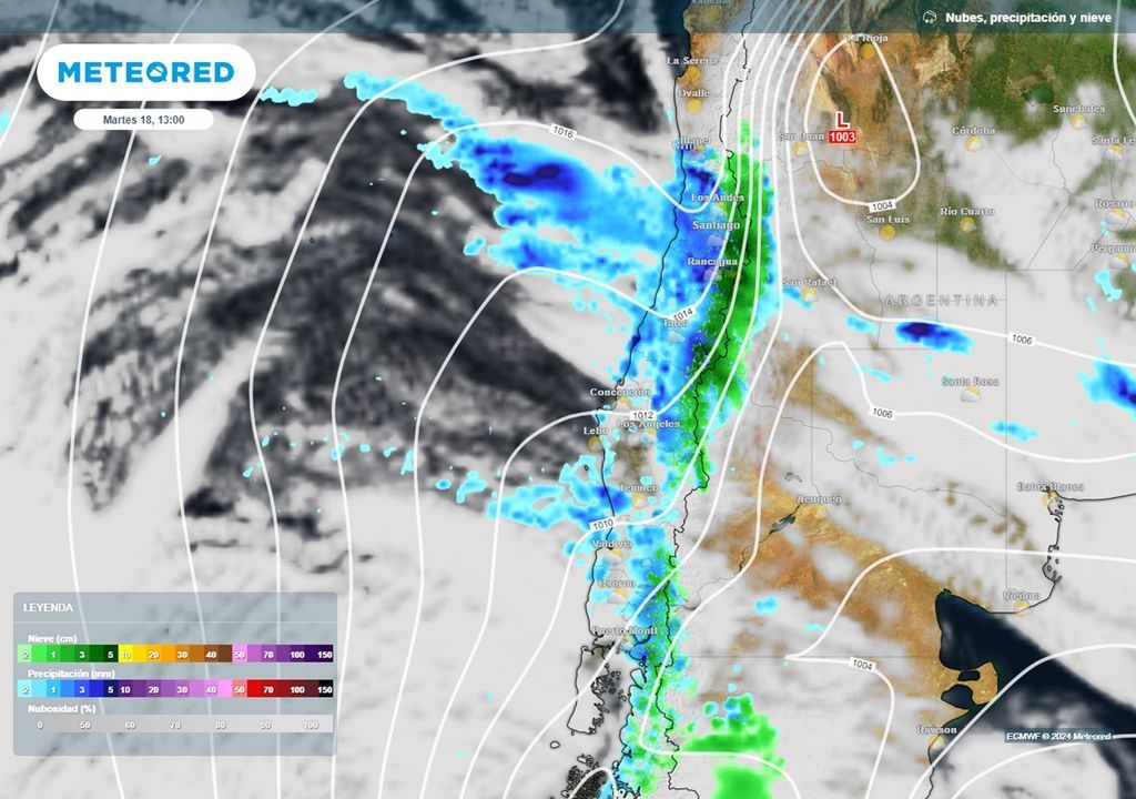
During the same Monday, the rainfall will be projected through the central zone, leaving between 15 to 30 mm of accumulated precipitation during that day in sectors of the Ñuble.
In the afternoon, the rains will extend until regions of O’Higgins, Valparaíso and Metropolitanarainfall that will increase in volume during the early hours of Tuesday the 18th.
Viviana Urbina’s forecast for the second half of June: the rain corridor will remain active
The front system will move to the south of Coquimbowhere rainfall amounts of between 10 and 25 mm in sectors south of Illapel.
This first front system of the week will remain on the north center at least until next Wednesdayproviding showers since early Tuesday morning over the central area of the country.
Coastal cities of the Valparaiso Region will add between 15 and 30 mm throughout the rain event that will affect that part of the country during the first days of next week.
The Metropolitan region you will receive between 30 to 60mm. The sectors of the foothills, the highest amounts will be recorded of this first frontal system of the week.
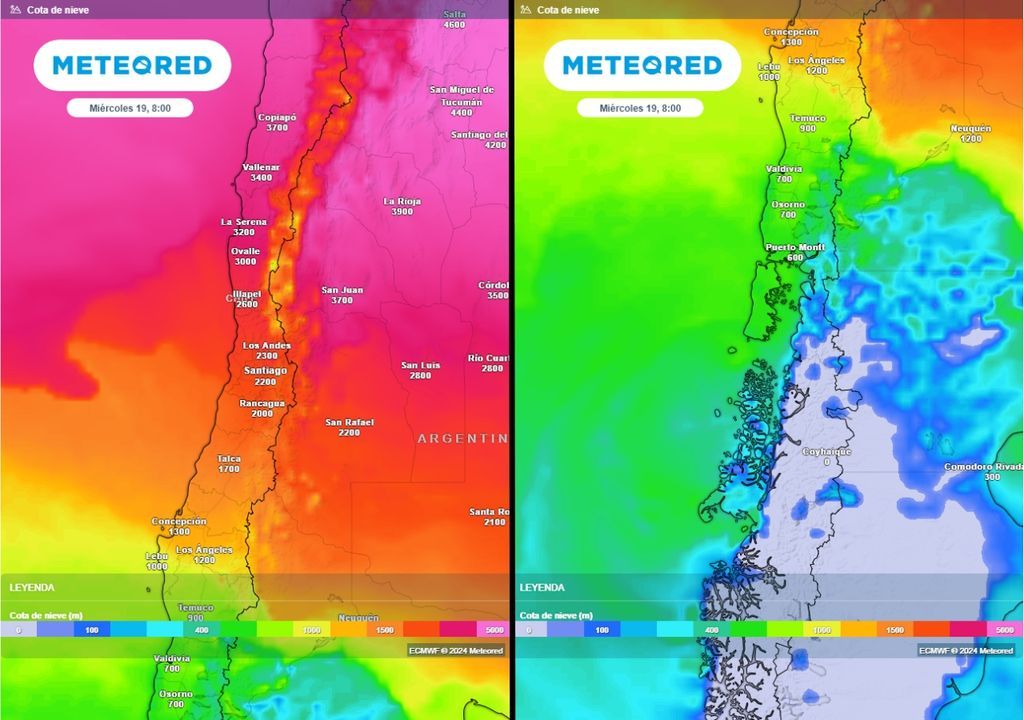
Frontal system will leave heavy snowfall
Until 1 and 1.5 m of new snow could let the new cold front pass through the country. The zero degree isotherm will be located near the 2,000 m in the central north of the country with the passage of the cold front.
Let us remember that the zero degree isotherm corresponds to the natural limit of liquid and solid precipitation within the cloud.
In it South Centralthe zero degree isotherm will descend to 1,000 to 1,500 m, while the cold air will carry the zero isotherm to the 500 to 700 m above the coastal mountain range of the Los Ríos and Los Lagos regions, in the postfrontal.
The instability after the front passes, he will be in charge of leaving snow showers over sectors of the Piuchén mountain rangeon the large island of Chiloé, which will also extend to the continental north.
Sectors of the Mahidanche mountain rangein the Los Ríos Region, also has the possibility of receiving snow and sleet showers on its highest peaks.
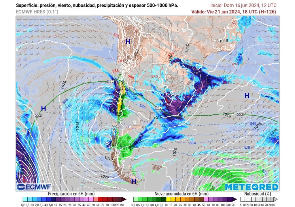
Postfrontal rapid before arrival of new frontal system and atmospheric river
During Wednesday, the rapid post-frontal will leave temperatures around 1 to 3 ºC over Valdivia and Osornowhile in Patagonia the cold will be much more intense, with minimums that could reach -8 to -12 ºC in various parts of the southernmost regions of the country.
The intense cold will be a prelude to the arrival of a new system front to the countrythis time accompanied by an atmospheric river more intense than the present at the beginning of the week.
He atmospheric river will accompany the frontal system that will arrive in Chile between Wednesday night and Thursday morning (20) to the southern regions of Chile, with an intense associated low pressure.
The low pressure will leave winds between 60 to 90 km/h in its approach to the regions of the Biobío, La Araucanía and Los Ríosconcentrated in the first instance with more intensity on coastal sectors.
This front system will affect the country until Saturday June 22leaving both liquid and solid precipitation between the Coquimbo and Aysé regionsn.
The heaviest rainfall is expected during Thursday night among the regions of O’Higgins and of Biobio.


