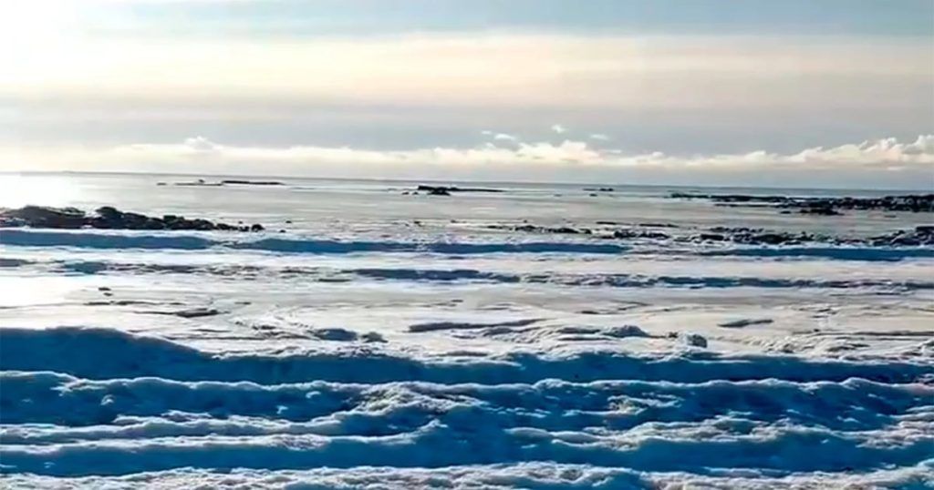
While concern continues about low temperatures in the Patagonia area, a new natural phenomenon occurred this Tuesday in Land of Firebecause the sea near San Sebastián, north of Río Grande, froze. In the images shared through social networks it is seen that the ocean waves turned into ice formations.
The place is located on the continuation of the National Route 3 in the island sector, just over 80 km from the city of Río Grande near the bay of San Sebastián. In this place is the most important area of a coastal reserve of international importance for the survival of various migratory coastal birds, reaching south to Cape San Pablo.
In addition, its climate is oceanic, humid with polar maritime influence. Extreme temperatures in summer are 10°C and 20°C. While in winter the minimum can drop to -14°C, although it usually remains constantly close to -9°C.
In this case, it is estimated that the main cause of the phenomenon has to do with the extremely low temperatures that they have been suffering, added to the particular climatic conditions of the place that favor the formation of ice in the sea, as explained from Radio 3 Trelew.
Likewise, it had already been mentioned in recent days that the area had suffered a significant drop in temperatures, so it is possible that this was one of the reasons that led to the sea water freezes. While it is not common for this to happen, extreme conditions can be conducive to this.
“Until the pipes froze and when that happens it is because the temperature is very low, it is very cold,” highlighted a resident of the area when asked about Infobae. To avoid this, the inhabitants know that it is advisable to let the water run a little to avoid freezing. He also added that “it is very normal” for something like this to happen in Río Grande.
In this sense, the Provincial Directorate of Sanitary Works and Services decided yesterday to restrict, from 2:00 p.m. to 8:00 p.m., the drinking water service in the central area of Ushuaia and in various neighborhoods to recover water storage levels. drinkable, they detailed in The diary of the end of the world.
At the same time, it should be noted that the Patagonia is going through one of the periods with the greatest snowfall in recent times and since National Meteorological Service (SMN) They anticipated that new snowfall, rain and strong winds are expected.
The lowest temperature this morning in Argentina was in El Calafate, which was -10.5°C. However, it was one of the least cold mornings in recent days, because Patagonia had temperatures of -15°C for a week. In this regard, it is important to highlight that this part of South America is experiencing an influx of cold air that is worthy of a winter.
Likewise, between June 10 and 20, The average temperature in the extreme south of the country was up to 4°C below average for this time of year, while in the center and north the opposite happened: up to 6°C above the average for this period.
In the same way, May reflected exceptionally cold weather conditions, promoting from the beginning the entry of very fresh air into the Patagonia region. Intense and unusual snowfalls were also generated in some sectors of the northwest of the region. Even some provinces such as Chubut, Río Negro, Neuquén, La Pampa, Córdoba, San Luis, Mendoza, San Juan, Tucumán and La Rioja, recorded the coldest May in the last 63 years.
Currently, the National Weather Service began a official yellow level alert due to strong winds with gusts locally exceeding 100 km/h on the central Patagonian coast starting Tuesday night, becoming generalized during Wednesday to a good part of the central and northern portion.
In the center and west of Neuquén the alert reaches orange level in the early hours of Wednesday, where the strongest intensities are expected, with gusts occasionally exceeding 120 km/h.
While Snowfalls of varying intensity will affect the Patagonian mountain range from south to north in the next 48 hoursand a few centimeters of accumulated snow could also be recorded again on the Santa Cruz and Chubut plateau.
In 2020, the Fuegian city of Río Grande was shaken by an extreme polar cold wave that seemed to have no end and generated unimaginable postcards at the beginning of winter.
On June 23 it snowed all day and during the early hours of Saturday the 27th the temperature broke a record when the clock struck 00 hours: it was -13.8 °C and the wind chill was below -20ºC. The last time with such a low record was in 1996.
The weather not only caused problems in traffic and in private homes – especially in the plumbing of houses – but also frozen a car and the water on the seashore.


