This end of June 2024 there will be mostly clear skies in much of Argentina but cold will be felt strongly throughout the day. Since, due to the effect of South windthere will be a low thermal sensation.
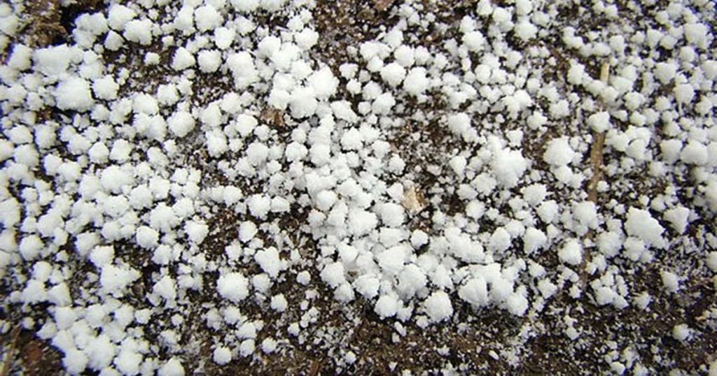
In some places of the Buenos Aires province the fall of sleet and observe graupel, which are grains of ice or soft hail.
He Sundayaccording to him National Meteorological Service (SMN), frost will be widespread during the morning in the center and northeast. It could be one of the coldest mornings you will have of the year.
Negative temperatures will also cover Uruguay, and even southern Brazil. It is due to the cold polar air that entered the Pampas region of Argentina last Thursday.
The graupel are the grains of ice. It is also called soft hail, small hail, light hail either small hail. It is formed by the precipitation of white ice balls, which fall irregularly.
The grains are 5 millimetres or less in diameter. They form when supercooled water droplets in clouds condense around an ice crystal.
Hail, snow and graupel are part of the precipitation phenomenon. In the case of hail, it is formed when raindrops generated in the clouds usually pass through strong cold currents. Then these droplets reach the surface in solid spherical shapes of at least 5 millimeters.
Hail generally lasts a few minutes. But it can cause severe damage to both inhabitants and houses, buildings, vehicles or crops.
Snow is small ice crystals. They are formed by freezing water in the troposphere, they can group together and reach the earth in the form of white flakes.
Graupel refers to precipitation that forms when supercooled water droplets condense on a snowflake, forming a ball of frost. The snowflake acts as a condensation nucleus in this process.
The term graupel is the German word for this meteorological phenomenon. Graupel is sometimes called small hail, although the World Meteorological Organization (WMO) defines small hail as snow balls encapsulated by ice, a precipitation halfway between graupel and hail.
“Snow forms inside the cloud and falls as a snowflake. On the other hand the Graupel is a raindrop that freezes due to very low temperatures.“, said to Infobae the SMN communicator, Cindy Fernandez.
In some areas of the province of Buenos Aires, graupel could be registered. According to Fernandez, “in all the southern coast of Buenos Aires until Mar del Plata today is raining. As temperatures drop overnight, rain could turn to sleet, snow or graupel. The probability of occurrence is the same throughout that sector. The probability is low to medium.”
He added: “The sleet or moments of rain could become graupel during Friday night and early Saturday morning.” Also in the northern coast of Patagonia the same phenomenon is expected.
It is not ruled out then that graupel could be registered in the area of the city of Claromeco. It could also be observed in the segment between Three Arroyos and Necochea or in Mar del Plata.
In the town of Window Mountain Rangepart of Tandil and in Mountains of the Fatherswhich is a town in the district of General Pueyrredón, the surroundings could be seen white due to the graupel. “But it is very unlikely that this will happen, since the chance of precipitation is almost zero at night,” he said.
As reported Infobae on June 27, meteorologist Sergio Jalfin He anticipated that “for winter 2024 temperatures are projected – at least at the beginning – below average.”
“In fact, this week and next are two weeks with temperatures below average levels for this time of year – he clarified – So a winter is expected that at first will start very cold and then the temperatures will be a little more adjusted to what is the time of year.”
The coldest of winteraccording to the specialist, It would be taking place in the last week of June and first week of July.


