

As we approach the end of the first half of this year, which has been extremely eventful due to the intense rains in the central and southern areas of the country, our reference model from the European Center for Medium and Long-Term Forecasts (ECMWF) tells us the first trends of what could happen in Chile during July 2024.
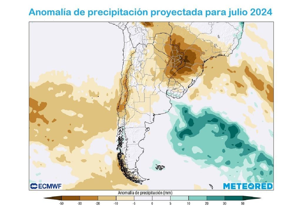
For the seventh month of the year, they are projected negative anomalies for the meteorological variable precipitation, condition that would be considerable in the foothills sector that extends from the Coquimbo Region to the Maule Region. They join this scenario the regions of Ñuble, Biobío and Magallanes.
What do these negative anomalies mean? That the amounts of rainfall would be lower than normal climatological values and, therefore, the passage of frontal systems over the central-southern zone of Chile would decrease in frequency, compared to what was experienced during June 2024.
On the one hand, if this climate projection indicated by our reference model is fulfilled, It will be a “respite” for the regions which were strongly affected by the incessant rains of recent weeks.
| City | Amount of water fall (mm) normal for july | Minimum temperature (°C) normal for july | Maximum temperature (°C) normal for july |
|---|---|---|---|
| Arica | 0.5 | 14.6 | 18.2 |
| Iquique | 0.1 | 13.9 | 17.8 |
| Calama | 1 | -0.4 | 21.1 |
| Antofagasta | 0.4 | 11.7 | 16.5 |
| Easter Island | 113.1 | 15.9 | 21.2 |
| The Serena | 17.1 | 7.4 | 15.4 |
| Valparaiso (Rodelillo) | 89.3 | 7 | fifteen |
| Santiago (Q. Normal) | 50.4 | 3.8 | 15.7 |
| Santo Domingo | 74.7 | 5.3 | 14.9 |
| Juan Fernandez | 130.5 | 10.6 | fifteen |
| Curico | 102.7 | 3.5 | 12.3 |
| Chillan | 149.3 | 3.5 | 12.1 |
| Conception | 168.1 | 5.7 | 13.3 |
| Valdivia | 265 | 4 | 10.8 |
| Osorno | 162.2 | 3.2 | 10.7 |
| Montt port | 177.4 | 3.5 | 10.2 |
| Coyhaique | 118.7 | -0.4 | 5.8 |
| Balmaceda | 65.2 | -2.7 | 4.3 |
| Punta Arenas | 30.9 | -0.7 | 4.2 |
| Precipitation (mm) and extreme temperatures (°C) for some cities in Chile corresponding to the month of July, according to the 5th Normal (1991-2020). Source: Chilean Meteorological Directorate (DMC). | |||
On the other side, there are regions that this forecast does not favor them, since the level of their reservoirs continues to present deplorable conditions, as is the case of the Coquimbo Region.
The only region that could present amounts of water fall slightly higher to normal climatological values is the Los Lagos Region during July 2024.
In the northern area, The regions of Arica and Parinacota, Tarapacá, Antofagasta and Atacama would present rainfall around normal climatological values, which are mainly associated with the drizzle generated by the stratus-type cloudiness that accompanies the coastal trough.
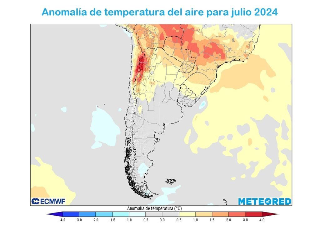
Meteorological frosts would increase their frequency in much of Chile during July 2024
From the northern gate of Chile to the Atacama Region, Our reference model projects air temperatures above normal climatological values, a meteorological condition that would be extremely noticeable in the foothills of the Antofagasta and Atacama regions.
The thermometers would register figures around climatological values normal between the regions of Coquimbo and Magallanes. In this direction, analyzing on a shorter time scale, the ECMWF model tells us that during the first half of July there would be meteorological frosts in this geographical section.
This atmospheric condition is associated to the displacement of high pressures with cold characteristics that, in addition to generating winter frosts, favor the increase in levels of polluting gases. Therefore, air quality would be affected, mainly in cities located in basins. where there is no good ventilation.


