


Still The country has not yet recovered from the heavy rains that is leaving the current frontal system, which arrived with an atmospheric river during the evening of Tuesday (25), and that has caused the overflow of some rivers and estuaries in the La Araucanía Region.
There are several yellow alerts issued by SENAPRED, in addition to two red alerts in force: one for the province of Cautín and Freire, for the overflow of the Pelales estuary, which has flooded homes and properties; A second red alert is in effect for the Increase in the flow of the Mahuidanche River in Santa Anaplacing the commune of Pitrufquen on high alert due to the potential damage that the possible overflow of the watercourse can cause.
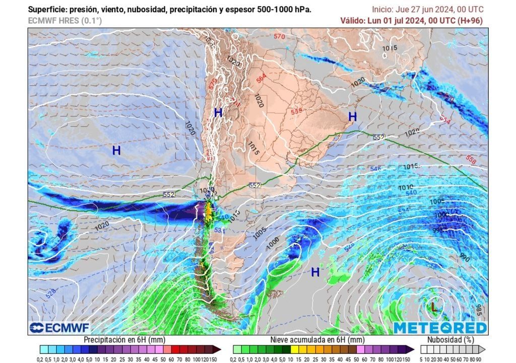
And although already The rains associated with this atmospheric river should decline during the day on Thursday (27)moving to a condition of high pressures associated with the entry of a mass of cold air during Friday (28th) that will leave frost in the southern area, our reference model indicates the arrival of a new system that will couple, once again , still new river of water vapor that moves through the atmosphere.
Frontal system and atmospheric river arrive with high zero isotherm
The main low pressure of a frontal system will reach Patagonia during Saturday (29) and will quickly advance with precipitation towards the south of the country, where it should leave the first rains during the early hours of Sunday (30th) in sectors of Los Lagos and Los Ríos.
During Sunday, the frontal system will advance through the Los Ríos Region towards La Araucaníawhere it will leave high accumulated rainfall.
The zero degree isotherm will be located between 2,000 to 2,500 m above the Los Ríos Region during Sundaywhen you concentrate the peak of rainfall in that part of the country.
The frontal system will reach this part of the country with a high zero isothermhence The precipitation that will fall on the area will be mainly liquidof the rainy type and intense showers.
Furthermore, the zero isotherm is considered the border zone between solid precipitation -about her- and liquid —below this level—.
This part of the country – affected for several weeks by successive and intense rains – has its soils waterlogged and saturated by the excess rainfall received, so the Rainfall that occurs in the area tends to flow superficiallycausing rivers, estuaries and various water courses to rapidly increase their flow.
Heavy rains in a short period of time
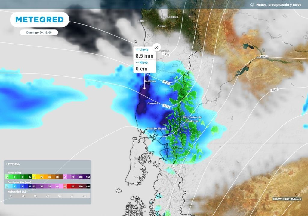
The advance of the frontal system, already coupled to the atmospheric river, will leave heavy rain in a few hours. They will be heavy showers those that can be registered during the day of the Sunday over sectors of Los Lagos and Los Ríoswhile the front system advances towards the Region of La Araucanía.
According to estimates provided by the ECMWF model, the showers could accumulate more than 8 mm per hour in sectors of the coastal mountain range of the aforementioned section.
Between Sunday night and the early morning of next Monday, July 1, the frontal system should leave intense rainfall over some sectors of the La Araucanía foothills. In the Around Pucón, between 35 and 55 mm are expected of rain accumulated between midnight and early Monday morning.
To what region will the frontal system advance?
The impact on this frontal system could reach to the Ñuble Region early next week. The Biobío Region will also feel the effects of the advance of the frontal systemHowever, in this section closest to the southern center of Chile, precipitation should be less intense.
Is there a possibility that rainfall will reach the central north?
For the moment, the dominance of high pressures will be stronger over the central north of the country, preventing the advance of the frontal systems towards that part of the national territory.
The information we have from the ECMWF models indicates that The first week of July will be without precipitation about the regions of Valparaíso, Metropolitana and O’Higgins. Great part of Maule Region will also enter a drier regime in the coming days.
Sources and references of the news:
– SENAPRED: Alerts.
– (CR)2: Weather Visualizer.


