It is a Tuesday morning with a little less cold in much of Argentina compared to Mondayand this is explained through the wind factor, both by its increase in some regions and by its notable decrease in others.
In Patagonia, an extremely cold period was left behind in the southern portion that will be difficult to forget, with marks of up to almost 20 °C below zero and persistence for a continuous week of negative temperatures in some points. Today, Tuesday, although it is another cold morning where some points drop below -5 °C, In general, the increase in the west wind that is beginning to be recorded is the reason that temperatures recover a little.
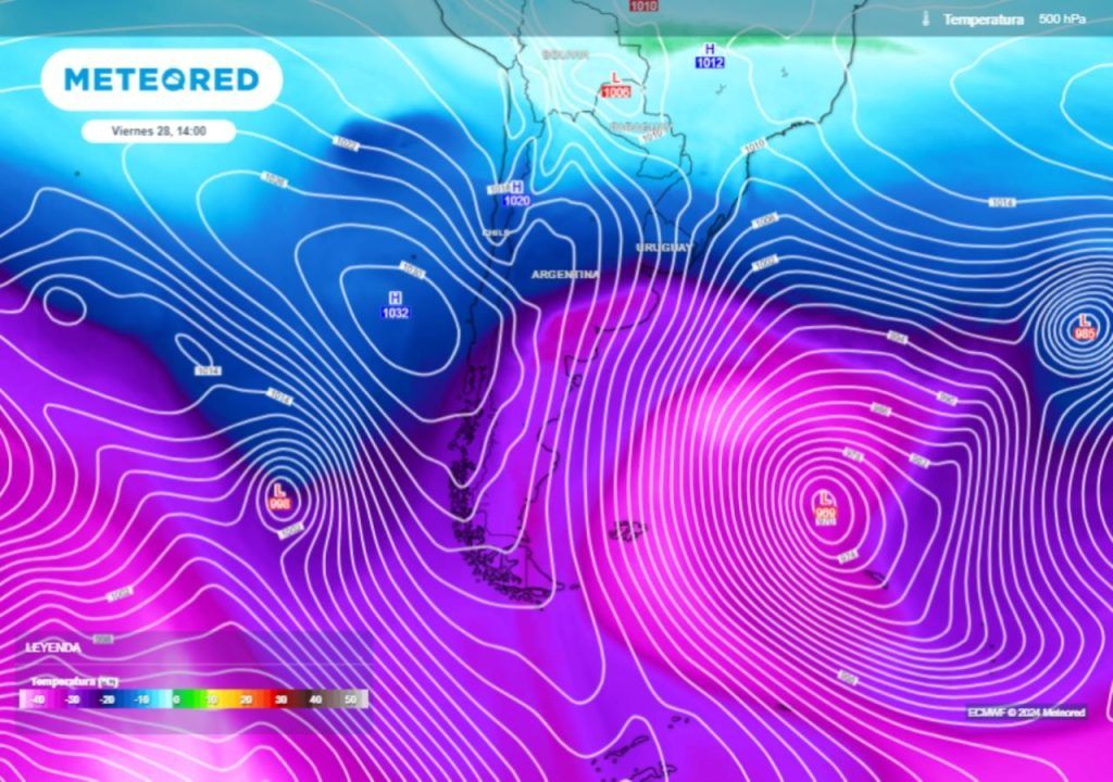
In the central regionOn the contrary, the wind has decreased compared to Monday, due to the entry of a high pressure system centered early in the morning over the province of Buenos Aires with central pressure close to 1030 hPa. Although it is a similarly cold morning in real temperature values to that of Monday in the central region of Argentina, The decrease in wind helps to ensure that the thermal sensation does not skyrocket compared to the real temperature., as happened on Monday. This clearly reduces the feeling of cold this Tuesday.
In it northern argentinafor its part, dawns with quite cool temperatureswith marks that we can locate as very high in the north of Misiones, around 15 °C.
Ahead we have a mix of meteorological phenomena to highlight this week in Argentinawhich includes precipitation, both rain and snow, strong winds, a temporary spike in temperatures, and finally a new entry of cold air that promises to bring polar mornings at various points during the next weekend.
New wind and snow storm in Patagonia, with orange alert
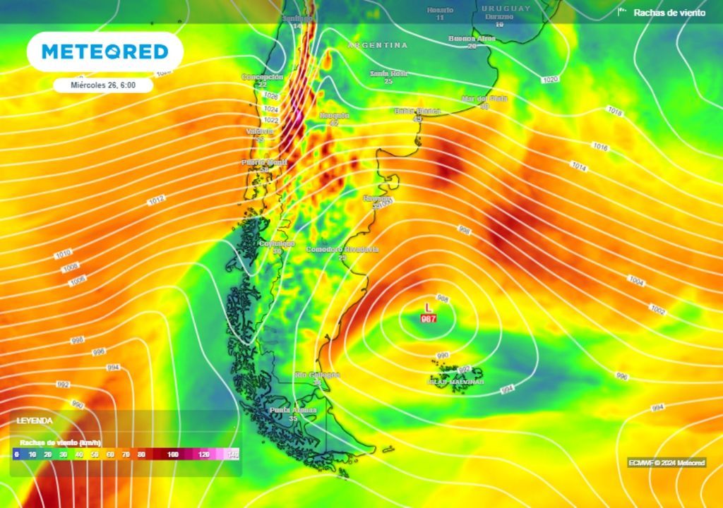
Between this Tuesday and Wednesday there will be a new deterioration in the weather in Patagoniawith a low pressure center entering and associated with the increase in west wind that is recorded.
The National Meteorological Service initiates an official yellow level alert for strong winds with gusts locally exceeding 100 km/h on the central Patagonian coast starting Tuesday night, becoming widespread on Wednesday to a good part of the central and northern portion. In the center and west of Neuquén the alert reaches orange level in the early hours of Wednesday, where the strongest intensities are expected, with gusts occasionally exceeding 120 km/h.
Snowfall of varying intensity will affect the Patagonian mountain range from south to north in the next 48 hoursand a few centimeters of accumulated snow could also be recorded again on the Santa Cruz and Chubut plateau.
Tuesday with deteriorating weather and rain in Buenos Aires and the Litoral
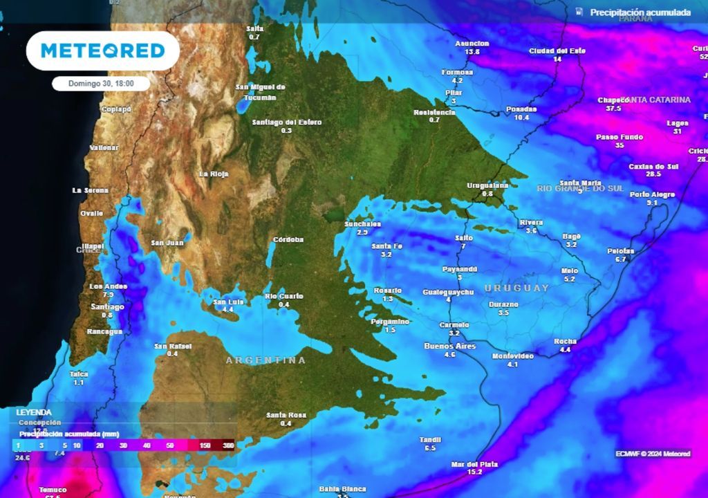
In the center and north of Argentina, the crossing this Tuesday of a disturbance at altitude will cause a temporary increase in cloudiness, finding, in particular, on the coast and the north of Buenos Aires conditions prone to some precipitation..
After a fairly cool Tuesday afternoon, it is likely that the north of Buenos Aires, Capital Federal, Santa Fe, Entre Ríos, Corrientes, Misiones, and the eastern part of Chaco and Formosa register rain and drizzle between night and dawn, with a tendency to improve starting Wednesday morning.
After that, the north-northeast wind will strengthen in Argentina, responsible for bringing a brief respite in terms of low temperatures and making the atmosphere much warmer for Thursday.
Polar cold front bringing frigid temperatures for the weekend in Argentina
By the final stretch of the week, the low pressure system that crossed Patagonia will have deepened noticeably in the open waters of the Atlantic, producing a strong current of southern wind from behind that will drive an air mass with polar characteristics from high latitudes towards the center and north of Argentina.
The cold front that will lead this polar advance will begin to arrive in the central area of the country on Friday, producing a marked change in winds to the south with gusts, and a sharp drop in temperatures. In the coastal area of the province of Buenos Aires, moderate intensity rains and showers will be recorded.
Saturday will dawn with very low temperatures in the center and north of Argentina, but Basically, the low thermal sensations will stand out, as a result of the moderate or regular wind that will continue to blow from the south.. For Sunday there will be a probable temporary decrease in wind intensity, and this will help make it another icy dawn in much of Argentina.
We keep you informed, stay connected with Meteored Argentina.


