

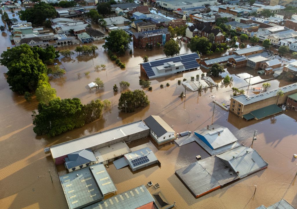
Before a precipitation event, today it is possible to find a wide variety of forecast services that indicate when, where and how much rain will fall, but it is more complex to know How much has been accumulated in each sector and if that poses a riskfor example, flooding and flooding.
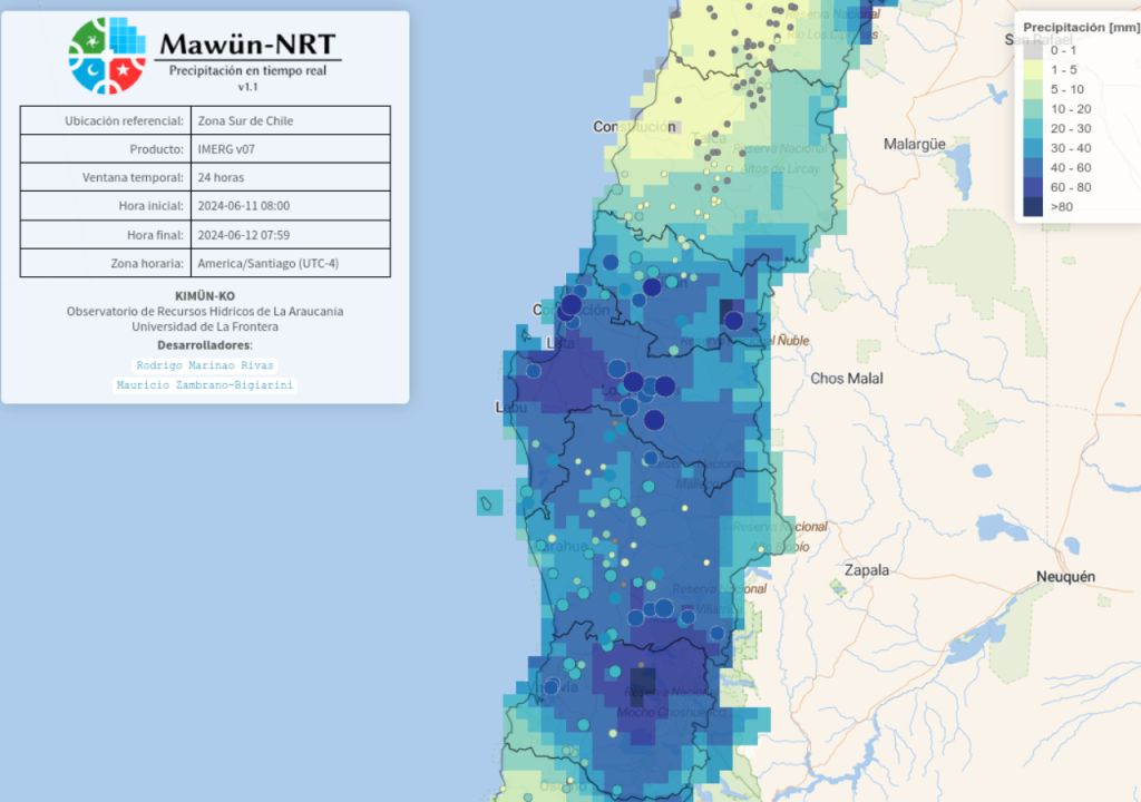
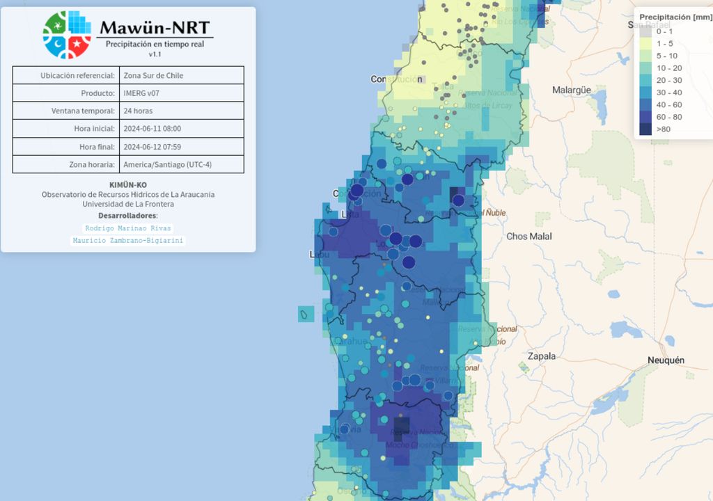
Motivated by the lack of information about the accumulated water After the precipitation events in the country, a group of researchers from the Water Resources Observatory of the Department of Civil Works Engineering of the University of La Frontera (Kimün-Ko), in collaboration with the Climate Research Center and Resilience [(CR)2]created the Mawün-NRT platform, an online, publicly accessible service that allows for almost real-time monitoring of the intensity and spatial distribution of rainfall anywhere in continental Chile.
Mawün-NRT (rain in Mapuzungun + the acronym for near real time), allows you to interactively view estimates of total precipitation fall during and after an event, complementing the information offered by weather forecast applications.
“When these extreme events occur, like those that occurred in the previous weeks, there is a lot of information about what is going to happen, but then there is no information about what really happened, and when it is delivered it is only at some very specific stations. But Precipitation is distributed super-variably in space and time”says Mauricio Zambrano-Bigiarini, an academic at UFRO and one of the creators of the platform.
Thus, the service complements existing platforms –like Vismet, from [(CR)2]–, which show what is happening in the weather stations installed in the country. But, as most of the stations monitored are on the coast and the central valley, Mawün-NRT eliminates information gaps in those areas where there are no stations – such as many sectors of the mountain range, for example – using global products. , which provide precipitation estimates based on satellite data, atmospheric reanalysis and other stations.
Informed decision making
Mawün-NRT is open and free for any user. The platform is interactive and provides a characterization of the total water fall over a geographic area, useful information for better decision-making in public services, such as the activation of early warnings and the management of water resources; also for researchers dedicated to the study of precipitation and its impact; companies and the general public.
“We decided to make three specific products available that are cutting-edge so that the general public and, mainly, people dedicated to science and in public services, in charge of monitoring what is happening at events, can have information on how much fell in any point in the territory. It’s not really a warning system, but can give a good idea of the sectors where the accumulated precipitation in the last 24, 48 or 72 hours has been quite high.to and, therefore, they are quite susceptible to flooding,” he indicates.
The team aims to develop a flood alert system in the medium term, for which they need to evaluate the products that will make it up. “Having a platform that is friendly, that allows us to see the spatial distribution during the actual occurrence of the events, has allowed us to know that there are products that work much better than others and, therefore, are good candidates to be used as forcing in a future flood warning system”says Zambrano-Bigiarini.
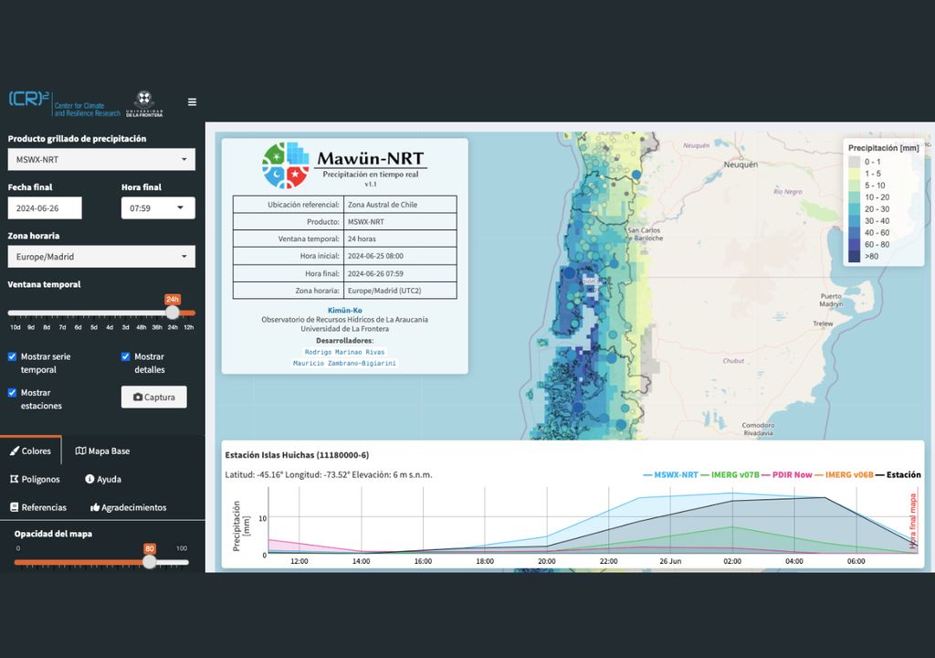
In this first release, Mawün-NRT includes four state-of-the-art precipitation products: near real-time multi-source weather, GPM integrated multi-satellite precipitation retrievals, PERSIANN dynamic infrared precipitation rate, and GPM integrated multi-satellite precipitation retrievals. In addition, it allows viewing the hourly precipitation data recorded in various rain gauges belonging to different national institutions.
“We hope that it can be effectively used by people who make decisions., because despite being a product that is oriented to almost real time, and the main utility is to know where it is raining now and how much it is raining, you can also go to past events. If you want to do an analysis, for example, to know how much precipitation caused a flood, it can also be done,” he says.
You can access the Mawün-NRT platform In the next link.


