


After intense years marked by the megadrought, 2024 has been a rainy year, there is no doubt. To the date, accumulates 199.2 mm of water fall in Santiago, which means a surplus of 90.1%.
And after the recent rainfall recorded in Santiago and the south-central area, the capital you will receive a new front system, the first days of next week, to which a second could even be added, on the weekend, which would increase the numbers even more.
The Meteorological Directorate of Chile points out that indeed It would rain on Tuesday and Wednesday. Rainfall has not yet been established in the capital for next weekend.
For its part, Meteored is more daring in its climate forecast. Indicates that the first frontal system would begin on Monday, and it would extend all of Tuesday, and part of Wednesday. To this he adds that it would also rain on Friday and Saturday, although it should be noted that with a week in advance, there are possibilities of variations in the forecast.
The first event would total 44.9 mm, while the second 34.3 mm, reaching 79.2 mm, which would make June 2024 one of the rainiest in recent years, and possibly the entire registry.
The meteorologist of the Huinay PUCV-Enel Foundation, Miguel Fernández, indicates that important activity is detected over the ocean in a succession of frontal systems that are being helped by an anticyclonic block in the polar zone and with it the imminent arrival of a new pulse for Monday afternoon, June 17.”
Paula Santibáñez, head of the Climate Observatory of the Faculty of Natural Sciences of the San Sebastián University, also maintains that a new frontal system is developing over the Pacific Ocean, which would begin to leave rainfall between Monday and Wednesday of next week,” adds Santibáñez.
Fernandez confirms the existence of two possible frontal systems, pointing out that a third pulse could arrive on June 21 (considering the recently recorded one as the first).
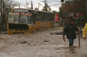
According to the Quinta Normal station of the Chilean Meteorological Directorate (DMC), the last frontal system that affected the south-central area of Chile left a record of 68.4 mm in the capital.
The statistics indicate that On Wednesday 26 mm were recorded, on Thursday 42 mm and today, Friday, 0.3 mm.
Despite the abundant rainfall, Raúl Cordero, a climatologist at the University of Santiago, considers that it was in the lower part of the forecast range, and did not manage to displace the event that occurred between May 20 and 22, as the one with the highest rainfall in the capital so far this year.
Cordero clarifies that in other regions, it has been the most intense recently, for example, in La Serena. “But in the south, for example, it has not been comparable to what happened in August 2023. Fortunately, It has not been a record event for much of the country″.
Fernández points out that “The central area of the country will continue to be affected by successive frontal systems”.
The other good news is that thanks to this event, June will end with rainfall above typical values. “That is, we are going to conclude a first semester, in terms of rainfall, very good for the entire country, which will close a first semester without a significant deficit in any region,” says Cordero.
In the middle of the frontal system that crosses the south-central area of the country, the DMC revealed how the weather will behave during the winter (June, July, August). Although it seems unlikely today, the report indicates that it will be a season with below normal rains, and with a “strong” positioning of the La Niña phenomenon.
The document maintains that more and more the positioning of La Niña in the equatorial Pacific, where international models show a projection for the July-August-September (JAS) quarter of 69% probability of its presence. Since February of this year, it has been observed that negative temperature anomalies have begun to appear below the surface of the equatorial Pacific.
These anomalies account for the presence of oceanic Kelvin waves, that have been spreading and have advanced from east to west and that in their evolution favor the cooling of the sea surface. These data confirm that the La Niña forecasts have a physical basis and that the development of the phenomenon is imminent.
He adds that during winter, a greater amount of precipitation is expected compared to other seasons, mainly because the rains are more frequent and the temperatures are also colder.
However, in the regions between Atacama and Los Lagos, There is a high probability that the quarter will present a “Below Normal” condition. For example, in Santiago it is expected to accumulate less than 121 mm during these three months, in Chillán less than 399 mm and in Valdivia less than 698 mm. This does not mean that there will be no precipitation, but rather that the amount of accumulated precipitation will be below the climatological average for a normal quarter, the DMC report states.


